Forecasting cloud types is essential to determining precipitation amounts and intensities. The rule of thumb is the lower the cloud base, the higher the potential for precipitation intensity. Cumuliform clouds can grow to excess heights and are made up of much more moisture than stratiform clouds. Stratiform clouds are much thinner and produce steady precipitation. Don’t confuse rain intensity with rainfall amounts. Although stratiform clouds produce less intense rainfall, they can produce steady rain for long periods of time and therefore, much higher rain amounts.
Cloud Types
Cirrus/Cirrostratus (high etage). These clouds can be very extensive in the horizontal but are relatively shallow vertically speaking. Common vertical extents average from 1,000 to 2,000ft. Ci or Cs may be present alone or together in layers. The presence of cirrus clouds is typically associated with fair weather in the short term, but they often signal an approaching warm front or a change in weather within 24–48 hours.
Classic saying:
“Cirrus clouds mean fair weather now, but foul weather later.”
Key weather associations:
Characteristic
Typical Weather
Current weather
Clear, sunny, and pleasant (cirrus are high and thin, don’t block much sun)
Temperature
Usually mild to warm (especially ahead of a warm front)
Wind
Light to moderate, often increasing aloft
Humidity
Dry at the surface, but increasing moisture aloft
Pressure
Slowly falling (barometer dropping gradually)
Forecast (12–48 hours)
Approaching warm front → clouds thicken and lower → rain or storms likely
Altocumulus/Altostratus (mid etage). These two cloud types can also be very extensive in the horizontal but the vertical extent of As averages from 1,000 to 2,000 ft. Ac tends to have a slightly greater vertical extent ranging on average from 1,000 to 5,000ft in depth. The presence of altocumulus clouds is typically associated with fair to pleasant weather right now, but they often act as a warning sign that the good weather won’t last much longer — usually 6–18 hours before a change.
Classic weather sayings:
“Mackerel sky and mare’s tails make tall ships carry low sails.” (Altocumulus often look like fish scales = “mackerel sky” → storm coming)
“Altocumulus in the morning, sailors take warning.”
Key weather associations:
Characteristic
Typical Weather
Current weather
Mostly sunny or partly cloudy, warm and nice (small gaps let sunshine through)
Temperature
Warm to hot in summer; mild in spring/fall
Wind
Light at surface, but moderate/strong aloft
Humidity
Moderate; feels a bit muggy
Pressure
Starting to fall steadily
Forecast (6–18 hours)
Approaching cold front or warm front → thunderstorms, showers, or a cool-down likely
Thunderstorm clue
If altocumulus clouds grow taller in the afternoon (“turrets” or “castellanus”), scattered thunderstorms are very likely later today
Nimbostratus (mid to low etage). Very extensive in both the horizontal and vertical. The average vertical extent is from 10,000 to 20,000 ft. Nimbostratus typically lowers over time due to falling precipitation. The presence of nimbostratus clouds means steady, long-lasting rain or snow is happening right now — and it’s not going anywhere soon.
Classic sayings:
“Nimbostratus = umbrella stratus.”“When the sky turns battleship gray and stays that way, pack a lunch — it’s raining all day.”
Key weather associations:
Characteristic
Typical Weather
Current weather
Overcast, gray, dreary — continuous moderate to heavy rain, snow, or drizzle
Duration
Usually 6–24+ hours of nonstop precipitation (not a quick shower)
Temperature
Cool to cold (often near freezing in winter → sleet or freezing rain possible)
Wind
Steady, moderate breeze (gusty under heavier bands)
Humidity
Very high — everything feels soaked
Pressure
Low and steady or slowly falling
Visibility
Poor (often <5 km / 3 miles in heavy rain)
Forecast
Rain/snow continues until the warm front or cold front passes — then it may taper to drizzle or clear slowly
Stratus/Stratocumulus/Cumulus/Cumulonimbus (low etage). For cumuliform clouds, the stability of a region will dictate both the horizontal and vertical extent. St (Stratus) is a stable cloud type ranging from 1,000 to 4,000ft in vertical extent. St can at times be very extensive horizontally. Sc (Stratocumulus) exists under stable conditions and is typically wider horizontally than deep vertically. The average vertical extent is between 1,000 and 4,000ft. Cu (Cumulus) and CB’s (Cumulonimbus) exist under unstable atmospheric conditions. The degree of instability dictates the extent of vertical development. The vertical extent can range from several thousand feet for Cu to 50,000ft or more for CB’s.
Stratus Clouds – The blanket of gloom
Classic sayings:
“Stratus = status quo.”“When the sky looks like wet concrete, don’t expect sunshine soon.”“Stratus in the morning, sailors take no warning — just boredom.”
Characteristic
Typical Weather
Current weather
Overcast, gray, lifeless sky Light drizzle, mist, or fog; sometimes completely dry Feels raw, chilly, and damp
Duration
Hours to several days (especially along coasts or in winter “gray lockdowns”)
Temperature
Cool to cold; often just above freezing → freezing drizzle possible
Wind
Light or calm at surface (can be windy aloft)
Humidity
Near 100 % — clothes never dry, car windows fog up
Pressure
High or stable (inversion traps moisture) OR slowly rising behind a departing storm
Visibility
1–5 km in mist; can drop to <1 km in hill fog or thick stratus
Forecast
Little change until a front arrives → Warm front: lifts into nimbostratus → steady rain → Cold front: breaks into stratocumulus → sun returns
Stratocumulus Clouds – The “mostly harmless” sky filler
Characteristic
Typical Weather
Current weather
Mostly cloudy but not gloomy Patches of sun, soft shadows Occasional light showers or virga (rain that evaporates before ground) Feels mild and a bit muggy
Duration
3–12 hours typical; can cover the sky all day in spring/fall
Temperature
Comfortable — neither hot nor cold
Wind
Light to moderate breeze; sometimes gusty under shower patches
Humidity
Moderate to high, but not soaking
Pressure
Stable or slowly falling
Visibility
Good (10–30 km); only drops briefly under showers
Forecast (next 6–24 h)
Usually no drama → If rows align in “streets” → cold front + wind in 12–18 h → If thinning in the west → sunshine tomorrow → If building upward → possible cumulonimbus later today
Cumulus Clouds – The “perfect-day” clouds
Characteristic
Typical Weather
Current weather
Blue sky, bright sunshine, warm & breezy Low humidity, feels fresh and uplifting No rain right now
Duration
Morning → mid/late afternoon (then either vanish or explode upward)
Temperature
Warm to hot (classic summer postcard weather)
Wind
Light at surface, stronger aloft — makes cumulus “pop” like popcorn
Humidity
Low to moderate — hair stays perfect
Pressure
High or slowly falling
Visibility
Unlimited (20–100+ km) — mountains look razor-sharp
Forecast (next 3–12 h)
90 % great day → If tops stay flat & small → stays beautiful → If they grow taller than wide by 3 p.m. → thunderstorms likely by 5–7 p.m.
Cumulonimbus Clouds – Nature’s nuclear bomb in the sky
Characteristic
Typical Weather
Current weather
DANGER ZONE Heavy rain, lightning, thunder, hail, tornadoes, microbursts, gustnadoes Sudden darkness even at noon
Duration
30 min – 2 h per storm cell Lines or supercells can hammer the same area for 6–12 h
Temperature
Sharp drop (10–20 °C in minutes) under the gust front
Wind
Calm → 60–120+ km/h outflow in seconds Straight-line winds can topple trees
Humidity
100 % under the storm — then dry punch behind it
Pressure
Rapid fall before → sudden rise after gust front
Visibility
Drops to <200 m in heavy rain/hail
Forecast
More cells likely along outflow boundaries until sunset or front passes
Classic sayings:
“Anvil = run for your life.”“When the cloud eats the sun and starts flashing, you have minutes, not hours.”“Cumulonimbus doesn’t knock — it kicks the door down.”
Ceilings
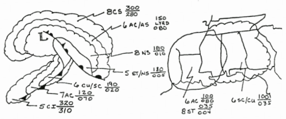
Basic Nephanalysis Criteria. Areas with ceilings less than 1,000ft are enclosed using a solid red line. Ceilings greater than or equal to 1,000ft but less than 3,000ft; enclose in scalloped blue. Ceilings greater than or equal to 3,000ft but less than 10,000ft; enclose with scalloped purple. Greater than or equal to 10,000ft; depict in scalloped brown.
Label ceilings with the following information: Cloud amount in eighths (octas). This is immediately followed by the two letter cloud type (Sc, Cu, As, etc.). If two cloud types exist in conjunction or are layered, list both and separate with a solidus (“/”). Follow cloud type with the height of the cloud bases and tops indicated in three digits (10,000’s, 1,000’s, and 100’s). Bases go under tops and are separated by a line (for solid decks). When multiple decks exist and aren’t separated by an appreciable distance, substitute the line with the abbreviation “LYRD”.
Above all else Be Consistent!!! Don’t label a blue scalloped area (which is reserved for the low etage) as being Ac or As (these are mid etage cloud types).
Precipitation Areas
Clouds And Related Precipitation Types. Cu of strong vertical extent can and often does produce showery precipitation. Cb’s are pretty much synonymous with thunderstorms and produce showery precipitation. Sc, which is not the result of a stabilizing (Sc from Cu) situation, can produce light precipitation of a continuous or intermittent character. Any precipitation that falls from St is in the form of drizzle or snow grains (the exception to this would be if the St were underneath Ns).
Precipitation Area Depiction. Outline areas of continuous precipitation with a solid green line and indicate type and intensity with the appropriate symbol(s). Use an alternating dash/dot green line to depict showery precipitation types and again use appropriate symbol(s) for type and intensity. When two types of precipitation are forecast for the same area, list the predominate type first and separate by a solidus (“1”). Separate areas of liquid and frozen types with a solid green line. Depict areas of thunderstorms with an alternating dash/dot red line and, over the appropriate red thunderstorm symbol, indicate max top(s) using three digits in black.
Once again, consistency is a must! Don’t depict precipitation under cloud types that won’t produce precipitation (i.e., rain showers under a Cs canopy). Likewise, don’t indicate rain showers under strictly stable cloud types (i.e., rain showers under Ns alone).
Basic Nephanalysis Criteria
(The 10-step “cloud-to-weather” cheat sheet used by meteorologists, pilots, mariners, and forecasters worldwide)
1. Height (How high is it?)
Height
Cloud types
Quick test
High (>20,000 ft / 6 km)
Cirrus, Cirrocumulus, Cirrostratus
Wispy, ice, sun-dogs, no shadow on ground
Middle (6,500–20,000 ft / 2–6 km)
Alto-cumulus, Alto-stratus
Thumbnail/fist at arm’s length, faint shadow
Low (<6,500 ft / 2 km)
Stratus, Stratocumulus, Cumulus, Nimbostratus, Cumulonimbus base
Strong shadow, hides hills
2. Shape & Texture
Shape
Means
Examples
Heap (puffy)
Unstable, rising air
Cumulus → Cumulonimbus
Layer (flat)
Stable, sinking air
Stratus, Altostratus
Wave/Roll
Wind shear
Altocumulus undulatus, Kelvin-Helmholtz
Fibrous/Wispy
Ice crystals + strong jet-stream wind
Cirrus, fall-streaks
3. Color & Brightness
Color
Interpretation
Brilliant white
Thick water droplets + direct sun → fair or growing fast
Gray
Water droplets blocking light → rain soon or already
Dark gray/black
Heavy rain/hail shaft underneath
Greenish
Large hail + dense water → severe thunderstorm
Red/orange at sunset
High ice clouds → jet stream strong, storm system 24–36 h away
When cold air moves from a cool land surface over a warmer ocean, it rapidly gains heat and moisture from below. This transfer destabilizes the atmosphere, causing rising air, deepening clouds, and...
Air masses are vast bodies of air that shape weather across the globe. Formed over uniform surfaces such as oceans, deserts, and ice fields, they carry distinct temperature and moisture...