
There are a total of six air masses that effect the weather in the United States. There are four primary air masses that impact the weather in North America year round and two air masses that are seasonal.
There are four primary air masses that effect the weather in the United States. These are the Continental Polar, Continental Tropical, Maritime Polar, and Maritime Tropical Air masses. These air masses form in their source regions and based on that region is how they get their names. The Maritime Tropical air masses are typically located off the southern east and west coasts. They are responsible for much of the rainfall in the United States due to moving the moisture from the oceans over land and then interacting with the Continental Polar or Continental Tropical air masses depending on the time of year and the season. Once any of these air masses start to move from their source region, this is when the atmospheric stability of the air mass is modified.
We first need to define what an air mass is and then determine its source region to identify what type of air mass it is and the stability of the air mass. Air masses are labeled based on their source region.
There are two primary air masses that effect the weather in the mid-west and eastern United states. The Continental Polar (cP) and the Maritime Tropical (mT). The Continental air mass will begin to drop south out of Canada and bring cold air to the south with a dominant high pressure system.
Semi-permanent high pressure systems determine migration of the air masses during the summer and winter months.
Air Mass – Definition
An air mass is a widespread body of air with similar temperature and moisture characteristics in both the horizontal and vertical (homogeneous). Air masses may cover several thousand square miles.
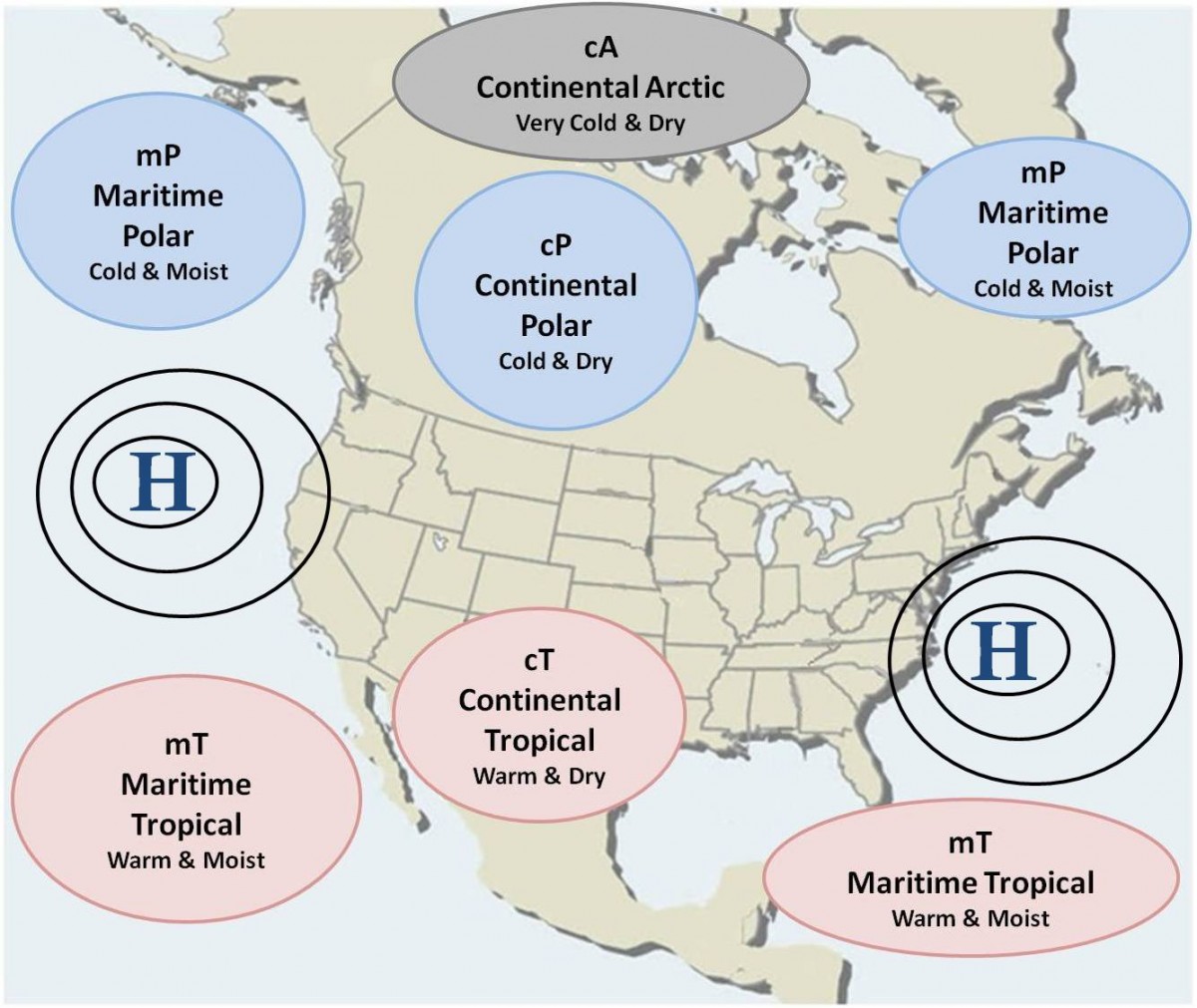
Locations Of Air Masses In North America
The geographical location where the air-mass formed is referred to as the Source Region. These regions have uniform surfaces of temperature and moisture characteristics. They are usually flat and uniform (all land or all water) and light surface winds. The properties of any air mass will be dependent upon where the air mass originates. Dry air masses form over land and moist air masses form over water.

Types Of Air Masses
Continental Arctic (cA)
The continental arctic (cA) air-mass forms in the frigid areas of the Arctic Ocean, Antarctica, Greenland, Northern Siberia, Alaska and Canada in the winter. These areas have a uniform surface, usually extremely cold and dry. The abundance of ice and snow, does not allow for increased moisture content because the area in most cases does not have unfrozen water.

When the continental arctic (cA) air mass does move south, it is the one that starts the frigid dry weather that we know as the polar vortex.
Continental Polar (cP)

This air-mass forms in the northern regions of Canada, Alaska, Siberia and sometimes northern Europe. You will notice an area of higher pressures in the same region where these cP air-masses form. This high pressure allows for the homogeneous area an air-mass needs to form. As the cold of winter settles in, the subsidence helps intensify the highs which also weaken in the warmth of summer. These air-masses are typically cold, dry and stable.
Maritime Tropical (mT)
The mT air masses are very warm and moist in low levels. There are likely inversions in this air mass during the evening that prevent moisture from reaching the higher levels in the troposphere. The eastern side of the subtropical high is more stable than the western side. This makes the eastern side drier than the western side where clouds and precipitation are common. Dew-point temperatures are greater than 60°F. These high dew points make it very uncomfortable in a mT air mass.

Maritime Tropical airmass will be very warm and humid. A “tropical continental” airmass usually covers much of the United States in the summertime. Other airmass types include “arctic”, “equatorial”, and “monsoon”.
Maritime Polar (mP)
The source region for the mP air mass is the cold unfrozen ocean areas poleward of 45°. It is associated with the subpolar lows which intensify and shift equatorward in the winter. They form from the modification of another air mass, usually continental polar or maritime tropical, which moves over the cold ocean areas. This is the predominate air mass west of the Rocky Mountains and in western Europe.

The Maritime Polar air mass over the North Pacific effects the weather in the upper northwest causing the rainy season. This air mass is also responsible for lake effect snow from onshore flow from the pacific.
Continental Tropical (cT)
The only real source region for cT air masses in North America is found during the summer in the desert Southwest and northern Mexico. Here the air is very hot and the air rises causing a low-pressure area. These lows are thermal lows and are called heat lows.

In the summer, there is a Continental Tropical (cT) air mass that settles over the south central United States and if the sub-tropical jet comes far enough north to cause the warm and dry air mass to push east, a dry line can be found at the leading edge of the air mass and this dry line in known to cause sudden severe weather in the south.
Weather Caused By The Continental Tropical (cT) Air Mass
This air mass forms in the summer and is unique due to dry nature and can cause the severe weather we see often in Texas.
An inversion is when temperature increases with height opposed to decreasing with height and this causes an inversion in the atmosphere that can trap warm moist air in the lower levels an with an approaching dry line acting in the warm moist air, it can cause the moisture to build up and when the inversion pops, a sudden explosive onset thunderstorms with severe condition and tornadoes can form.
Semi-Permanent High Pressure Systems
There are two semi-permanent high pressure systems. One over the Atlantic Ocean and one over the Pacific Ocean. These pressure systems migrate north and south during the winter and summer months. This migration allows the maritime tropical air masses over the oceans to move north or south as well. When the semi-permanent high pressure systems move south in the winter, they can be responsible for pumping warm moist air over land in the south east and west transporting the moisture needed to produce rain showers when interacting with the continental polar (cP) air mass to the north.
These High pressure systems can also collide with the Maritime Tropical air mass to the south which is warm and moist and cause unstable conditions. As the warm moist air is lifted up over the cold dry air clouds will for at the lifting condensation level and if there is enough moisture associated with the two air masses, rain and thunderstorms can develop.
These pressure systems are also responsible for steering hurricanes and tropical storms during Hurricane season. 1 June – 30 Nov.
Summary
Continental Polar/Arctic (cP or cA)
- Cold/dry air masses
- Originate over the ice/snow covered regions of northern Canada and Alaska
- Long, clear nights allow for maximum cooling
- Very dry
- Usually stay in place but occasionally break away and are carried southeast by the upper level winds
- Drops in toward the plains so there is not much terrain to impede it.
- Moderate (warm up) as they move southward – Particularly if they move over warm water
- Produce lake-effect snow up north
Maritime Tropical (mT)
- Warm/moist air masses
- Originate: Gulf of Mexico Sub-tropical eastern Pacific Western Atlantic
- Develop afternoon air-mass thunderstorms
- Very stable in the eastern region
- Dew points are in the 70’s causing an uncomfortable humidity
Maritime Polar (mP)
- Cool and moist in the low levels
- Greatest influence on the Pacific Northwest
- Cool, moist. and unstable
- Sometimes causes severe weather along the dry line in the southern plains.
Continental Tropical (cT)
- Hot/dry air masses
- Found in the desert Southwest and northern Mexico
- Responsible for summer drought conditions
- Very unstable in the low levels
- Precipitation usually evaporates before reaching the ground
Equatorial Trough (E)
- Source region is approximately 10°N to 10°S
- The weather is the same year round
- Will produce showers and thunderstorms mainly in the afternoon
- Unstable with high humidity
This High pressure system will then collide with the Maritime Tropical air mass to the south which is warm and moist and cause unstable conditions. As the warm moist air is lifted up over the cold dry air clouds will for at the lifting condensation level and if there is enough moisture associated with the two air masses, rain and thunderstorms can develop.
Recent Posts
Determining Severe Weather Based On Stability Indexes and Upper-Level Winds
There are several weather products used to determine the possibility of severe weather for an area. The most common and misunderstood by many weather enthusiasts is the Skew-T chart and the upper-air...
Tornado Basics, Severe Weather Preparation, & The Enhanced Fujita scale
Earth's weather can produce various kinds of windstorms which include waterspouts, dust devils and tornadoes. Although they have the common features of a column of rotating air, they are actually...