
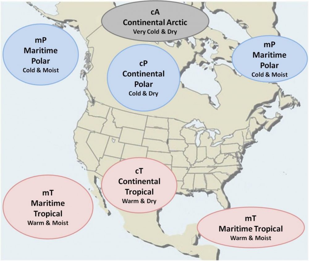
Primary Air Masses In North America
There are four primary air masses that impact the weather in North America. Continental Polar and Tropical air masses and the Maritime Polar and Tropical Air masses. The Continental Polar air mass dominates the United States in the winter due to the semi-permanent sub-tropical high pressure systems migrating south. In the summer months, the semi-permanent sub-tropical highs over the Atlantic and Pacific oceans migrate north and allows the maritime tropical air mass to bring moisture from the south. This also allows the Continental Tropical Air mass to form over Texas. When this hot and dry air masses migrates, the leading edge of the air mass is known as the dry line. With the right conditions, it can be a major factor as the trigger for severe thunderstorms.
Air Mass – Definition
An air mass is a widespread body of air with similar temperature and moisture characteristics in both the horizontal and vertical (homogeneous). Air masses may cover several thousand square miles.
Air Mass Locations
The geographical location where the air-mass formed is referred to as the Source Region. These regions have uniform surfaces of temperature and moisture characteristics. They are usually flat and uniform (all land or all water) and light surface winds. The properties of any air mass will be dependent upon where the air mass originates. Dry air masses form over land and moist air masses form over water.

Air Mass Classification
Air masses acquire their properties from spending days to weeks over the same part of the Earth, for example: over northern Canada, the North Pole, the tropical Pacific Ocean.
Air masses are classed in four categories with two main things to consider.
- Land or Water?
- Hot or Cold?
Four Categories
- c (continental) – source region over land
- m (maritime) – source region over water
- T (Tropical) – source region in the tropics -E (Equatorial) – extremely warm version of Tropical
- P (Polar) – source region in the polar regions – A (Arctic) – extremely cold version of Polar
Combine 1 or 2 with 3 or 4
Polar air masses become very cold, especially in the winter, because relatively little sunlight shines on the poles of the Earth, and so the air mass continuously loses infrared radiation to outer space, which cools it and there is little or no sunlight to offset that cooling.
Tropical Maritime airmass will be very warm and humid. A “tropical continental” airmass usually covers much of the United States in the summertime. Other airmass types include “arctic”, “equatorial”, and “monsoon”.
Geographical Indicators
This is also known as the Source Region Indicator. The geographical indicator denotes the region in which the air mass acquired its temperature properties.
Arctic and Antarctic (A) regions are very cold regions of the earth.
Polar (P) regions are cold but not as cold as arctic regions.
Tropical (T) regions are warm to hot depending on the location.
Equatorial (E) regions receive more energy from the sun and are very warm.
Air Mass Moisture Indicators
The moisture indicator denotes the type of surface over which the air mass acquired its moisture properties. There are two major surfaces on the earth, land and water. An air mass that forms over land is called continental (c) meaning dry. An air mass that forms over water is called maritime (m) and implies moist. Identifiers are used to tell us where the air-mass originated, moisture content and what type of modifications have taken place.
Region Identifiers & Characteristics
Continental Arctic (cA)
The continental arctic (cA) air-mass forms in the frigid areas of the Arctic Ocean, Antarctica, Greenland, Northern Siberia, Alaska and Canada in the winter. These areas have a uniform surface, usually extremely cold and dry. The abundance of ice and snow, does not allow for increased moisture content because the area in most cases does not have unfrozen water.

There are some particular characteristics this air-mass possesses. One of thee is it very seldom moves outside its source region. There are times though when it does move out, and the Central Plains as well as the northeast U.S. experience the coldest air of the winter. The air-mass is routinely very deep, cold and dry. Since the arctic air-mass stays in its source region most of the time it has the opportunity to become a very deep area of cold air.
The cold air extends very high into the atmosphere. This is in direct contrast to what you have been taught about cold air being shallow, but the cold air just keeps getting deeper, much like piling ice cream into a bowl. The ice cream may be cold but as you pile it on the higher it gets. The pressure system that is associated with the Arctic air-mass is the polar high which forms in the cold, dry, subsidence of the polar region. The polar high forms in the area of the Polar Cell.
Continental Polar (cP)

This air-mass forms in the northern regions of Canada, Alaska, Siberia and sometimes northern Europe. You will notice an area of higher pressures in the same region where these cP air-masses form. This high pressure allows for the homogeneous area an air-mass needs to form. As the cold of winter settles in, the subsidence helps intensify the highs which also weaken in the warmth of summer. These air-masses are typically cold, dry and stable.

In winter, very cold temperatures between -20°F and -40°F and even colder is observed in it’s source region. Even in these areas there is large water bodies but in the winter they are frozen and act as land. The skies are generally clear with possible scattered stratocumulus and good visibility. In industrial areas there may be problems with visibility due to smoke trapped under a subsidence inversion.
The air-mass has had the opportunity to develop and the long wave pattern changes. The cP air-mass moves out of the source region and begins to move south into the lower latitudes. Depending on the season it could be a cold winter blast or a cool, refreshing “breath of fresh air” in the summer.
As the air-mass moves south the gradient tightens due to the higher pressures in the cold air, the winds will become strong and very cold wind chills may be noticed. As the cold air moves south it runs into warmer, moist air and a polar front will develop, placing cP air on the +n side and mT air on the -n side.
The cP airmass is noted for it’s wide annual variations in all properties, especially temperature. These large differences make this airmass unique from all the other airmasses. Examples of these differences are the Siberian cP is coldest, while European cP is the mildest and-winter cP is more stable than summer cP.
Maritime Tropical (mT)
The source regions for mT air masses are the tropical and subtropical ocean where the subtropical high-pressure systems are found.

The mT air masses are very warm and moist in low levels. There are likely inversions in this air mass during the evening that prevent moisture from reaching the higher levels in the troposphere. The eastern side of the subtropical high is more stable than the western side. This makes the eastern side drier than the western side where clouds and precipitation are common. Dew-point temperatures are greater than 60°F. These high dew points make it very uncomfortable in a mT air mass.
During the winter months, temperatures average between 70°F and 80°F. The Gulf Coast of the United States often has mild temperatures, high humidity and considerable cloudiness. When there is an onshore flow, stratus and fog are common. Warm, moist air flows north from the Gulf Coast, overrunning the more dense cP air-mass. Thus the cause of cloudiness and precipitation in the central United States.
In the summer, the subtropical high is stronger and the clockwise flow draws mT air over the eastern part of the United States. Temperatures range from 85°F to 95°F and dew points are in the 70’s. Stratus and stratocumulus clouds form in the early morning hour along, the Gulf Coast. Because the air is unstable, afternoon air-mass thunderstorms develop. In the eastern portion of the subtropical high, the air mass is very stable; fog and stratus forms off the coast of California over the upwelling areas.

Maritime Polar (mP)
The source region for the mP air mass is the cold unfrozen ocean areas poleward of 45°. It is associated with the subpolar lows which intensify and shift equatorward in the winter. They form from the modification of another air mass, usually continental polar or maritime tropical, which moves over the cold ocean areas. This is the predominate air mass west of the Rocky Mountains and in western Europe.

The air mass is cool and moist in the low levels but dryer aloft. On a Skew-T diagram you will notice the moist conditions up to 750 mb. Above that, we see a subsidence inversion and much dryer air due to the downward motion of air. There is very little diurnal temperature variation.
The controlling factors that determine the characteristics of the air mass.
- The origin of the body of air in the mP source region
- The amount of time spent over the cold ocean water
- The trajectory or path taken by the other air mass as it passes thorough the mP source region.
As the continental polar air in winter moves across the North Pacific or North Atlantic Oceans, it takes a cyclonic trajectory around the subpolar low. This causes the air mass to become unstable aloft. The air surface, and is heated from below. This causes the air mass to become unstable in the low levels. As a result, convective activity develops and moisture is Typically cumulus and stratocumulus clouds form with showers and thunderstorms developing. However, the longer the air mass it becomes.
In the summer, the oceans are colder than the air mass coming off the continents. This air mass is cooled from below causing stable conditions in the low levels. In addition, the subpolar low weakens and moves poleward, so the upper levels are more stable. The resulting weather is different from in the winter. Fog and low stratus clouds are common over these areas.
When maritime tropical air moves over the North Atlantic in winter, it travels around the subtropical high in an anticyclonic trajectory. This makes the air mass stable aloft. The air mass is also stable in the low levels because the ocean is cold and it is cooled from below. The longer the air mass is over the ocean, the higher the cooling extends. It is often difficult to say for sure when the mT air mass became maritime polar.
The mP air mass has the greatest influence on the Pacific Northwest. It is cool, moist. and unstable. Temperatures are usually in the 40s and 50s. As the air moves inland, the coastal mountains force it to rise and much of its moisture falls out in the form of rain or snow. On the lee side, the mP air mass is modified and is drier. Sometimes this air mass collides with mT air in the southern plains along the “dry-line” and severe weather often occurs.
Along the East Coast, mP air moves southwestward toward the New England states. Since the North Atlantic is very cold and the path is short, wintertime Atlantic mP air masses are generally colder than the ones off the Pacific. Also, the United States in the prevailing westerlies, Atlantic mP air masses are not as common.
Continental Tropical (cT)
The only real source region for cT air masses in North America is found during the summer in the desert Southwest and northern Mexico. Here the air is very hot and the air rises causing a low-pressure area. These lows are thermal lows and are called heat lows.

Since cT air masses are hot and dry, it is not common in the winter season. In the summer, temperatures range from 95°F to 115°F during the day and in the 70s at night. There is a large diurnal temperature range. The air mass is very unstable in the low levels. But the air is so dry that few clouds form. The ones that do form are typically high based (8,000 to 10,000 feet). Occasionally isolated thunderstorms develop in the late afternoon but the precipitation usually evaporates before reaching the ground.
Equatorial Trough
The source region is located. The trough essentially a zone from approximately 10°N to 10°S where the equatorial trough migrates north and south with the sun. The weather is the same year round with 85°F to 100°F and low temperatures range from 75°F to 85°F. The air high temperatures ranging from evenly distributed throughout the troposphere. When the air is forced aloft, it will produce showers and thunderstorms mainly in the afternoon. There is little or no mass is unstable with high humidity variation in its properties.
Summary
Continental Polar/Arctic (cP or cA)
- Cold/dry air masses
- Originate over the ice/snow covered regions of northern Canada and Alaska
- Long, clear nights allow for maximum cooling
- Very dry
- Usually stay in place but occasionally break away and are carried southeast by the upper level winds
- Drops in toward the plains so there is not much terrain to impede it.
- Moderate (warm up) as they move southward – Particularly if they move over warm water
- Produce lake-effect snow up north
Maritime Tropical (mT)
- Warm/moist air masses
- Originate: Gulf of Mexico Sub-tropical eastern Pacific Western Atlantic
- Develop afternoon air-mass thunderstorms
- Very stable in the eastern region
- Dew points are in the 70’s causing an uncomfortable humidity
Maritime Polar (mP)
- Cool and moist in the low levels
- Greatest influence on the Pacific Northwest
- Cool, moist. and unstable
- Sometimes causes severe weather along the dry line in the southern plains.
Continental Tropical (cT)
- Hot/dry air masses
- Found in the desert Southwest and northern Mexico
- Responsible for summer drought conditions
- Very unstable in the low levels
- Precipitation usually evaporates before reaching the ground
Equatorial (E)
- Source region is approximately 10°N to 10°S
- The weather is the same year round
- Will produce showers and thunderstorms mainly in the afternoon
- Unstable with high humidity
Air Mass Climatic Controls
Relatively permanent factors which govern the general nature of the climate of a part of the earth are known as climatic controls. These factors control the variations of the climatic elements. They control the large-scale climate of an area known as macroclimate. These include:
- Latitude
- The general circulation and semipermanent pressure systems
- The distribution of the continents and oceans
- Large-scale topography and elevation
- Ocean currents
Latitude
Latitude controls the amount of available INcoming SOLar radiATION (INSOLATION) reaching the earths surface. The angle of incidence of the insolation reaching the earths’ surface varies with latitude, increasing toward the poles. As a result, the amount of solar radiation that strikes the surface decreases poleward. At the equator, the suns’ rays strike the surface directly, thus more energy reaches the earths’ surface. This variation of insolation makes latitude the most important of all climatic controls. Generally, higher temperatures occur at lower latitudes (near the equator) and lower temperatures occur at higher latitudes (near the poles).Of all the climatic controls, latitude has the greatest influence on the global distribution of temperature. As the earth revolves around the sun, the inclination of the earths’ axis with respect to its orbit is essentially the reason for the existence of seasons, thus the seasonal shifts in temperature.

Latitude also has an influence on moisture and precipitation. Generally, lower latitudes (where there is more ocean area than continents) will receive more precipitation than higher latitudes. This is also due, in part, to the global temperature distribution, with warm temperatures near the equator and cold temperatures found near the poles (warm air rises and cold air sinks).

Semipermanent Pressure Systems
The general circulation of the atmosphere refers to the flow of air over the entire globe. It serves to transport warm air from tropical regions poleward and maintains a return flow of cold air from the poles equatorward.
Three Cell Theory
In each hemisphere, three circulation cells act to redistribute energy. Tropical regions receive an excess of energy, while the polar regions have energy of zero deficit. The three cell that make up this theory is as follows:
- Hadley Cell – From the equator to 30° latitude
- Ferrell Cell – From 30° to 60° latitude
- Polar Cell – From 60° latitude to the poles
A model below depicts the air flow, in the vertical, above the earth’s surface.

Latitudinal differential heating influences the formation consequently, the direction of the prevailing winds. The equatorial trough is generally found between 10°N and 10°S. This is the region where the northeast trade winds of the northern hemisphere converge with the southeast trade winds of the southern hemisphere. It is a warm, moist region of rising air that produces a low pressure belt at the surface around the globe.
Subtropical highs develop at the surface near 30°N/S; a direct result of the convergence aloft between the Hadley and Ferrell Cells. These highs separate the easterly trades from the prevailing westerlies. They contain warm, dry regions of sinking air (subsidence). They are typically found over open ocean regions. In regions associated with the maximum subsidence (southeast quadrant), major deserts may be found over continents. The two semipermanent highs located in the northern hemisphere are the: (1) North Pacific High and (2) North Atlantic (Bermuda) High.
Subpolar Lows occur where the polar easterlies and prevailing westerlies converge (near 60’I\1/S). They are found in cold, stormy regions of rising air. Two semipermanent lows prevail in the northern hemisphere: (1) the Aleutian Low and (2) the Icelandic Low.
Polar Highs develop near the poles. These are a result of the convergence aloft and resulting subsidence between the polar cells. They are cold, dry and very stable regions of sinking air. The Arctic high, in the northern hemisphere, is strong in the winter and weakens during the summer. See the image below for typical locations of semiperminent pressure systems.

Semipermanent pressure systems influence climatic elements. They determine the prevailing, winds which, in turn, influence the availability of moisture, heat transfer and stability. Generally, the western side of subtropical highs are unstable; the eastern side is stable.

Distribution Of Continents & Oceans
The distribution of continents and oceans and their influence on temperature is second in importance only to latitude as a temperature control. Land areas display a larger temperature range than that of oceans and coastal regions.All phenomena connected with atmospheric moisture are related to the distribution of land and water vapor, condensation and cloudiness, and precipitation. Generally, the air water: evaporation and the air over oceans and coastal regions. The air over frozen areas is very over land areas is dryer than the air over oceans and coastal regions. The air over frozen areas is very dry.
The general circulation pattern will be affected by land/water distribution, effectively breaking up the belt of semipermanent high and low pressure systems in the mid-latitudes. The best example is over Siberia, where an intense high pressure system forms as a Quadrants Of The Subtropical High result of intense surface cooling in the winter, effectively breaking up the subpolar trough. Another example is over the western United States , where intense surface heating creates a region of low pressure over the deserts, effectively breaking up the subtropical high.Local circulations are also produced due to the temperature differential between land and ocean areas.
Large-Scale Topography and Elevation
Large-scale topography modifies other climatic controls. Mountain ranges which are parallel to the prevailing wind flow will not greatly modify climate. These mountains separate cold climates to the north from warmer climates south. Mountain ranges oriented perpendicular to the prevailing wind flow will have a great effect on the modification of the climate. For example, the Cascades in the Pacific Northwest force air to ascend over the range. Recall from Atmospheric Physics that as air ascends a mountain, adiabatic cooling and condensation occur, creating cloudiness and precipitation on the windward side. On the leeward side, the air adiabatically warms and dries.

Ocean Currents
Ocean currents are produced by the frictional effects of the winds circulating around the semipermanent pressure systems. They tend to follow closely the flow patterns around the system dominating the area. Warm currents are located on the east coasts of continents and cold currents on the west coasts (both hemispheres). These currents will have a definite effect on coastal climates as well as on high and low pressure systems that transit across them. A secondary cause of ocean current formation is the difference in density produced by variations in temperature and salinity (called salinity currents).
Upwelling is a process by which colder subsurface waters are brought to the ocean surface. This phenomena occurs on the west coasts of continents. Wind flowing around the subtropical high parallels the coast. Due to the rotation of the earth and resulting coriolis force, surface waters are transported to the right of the flow, away from the coast. As a result, cold water. from below the sea surface moves up to replace the exiting water. The weather associated with this condition is cool and damp. Fog and stratus are typical with little or no appreciable precipitation. Further inland, the weather is hot and dry.

Ocean currents have a major influence on climate, especially downstream from the current. Storms tend to follow warm currents. Western coastlines (between 20 and 40°) are bordered by cold upwelling. currents. The coast will experience small diurnal/annual temperature ranges. Periodic precipitation will develop in the winter, as storms migrate further south. West coasts (between 40° and 60°) are bordered by warm currents. Summers are cool, winters are mild and wet. Small annual temperature ranges are experienced.Eastern seaboards (between 20° and 40°) are bordered by warm currents. Moderate temperature ranges abound with warmer temperatures. Frequently, showery precipitation occurs due to the unstable air found on the western side of the subtropical high. East coasts (between 40° and 60° are bordered by cold currents. Winters are very cold, summers cool. Annual temperature ranges are large.

Recent Posts
Determining Severe Weather Based On Stability Indexes and Upper-Level Winds
There are several weather products used to determine the possibility of severe weather for an area. The most common and misunderstood by many weather enthusiasts is the Skew-T chart and the upper-air...
Tornado Basics, Severe Weather Preparation, & The Enhanced Fujita scale
Earth's weather can produce various kinds of windstorms which include waterspouts, dust devils and tornadoes. Although they have the common features of a column of rotating air, they are actually...