
Cloud formation and dissipation happens so often the the only time we really notice is when cloud droplets collide with each other and become too large to be held up by the air mass they are in and begin to fall as rain.
There are nine different types of clouds in each level (Low, Mid, & High). Clouds are all made of the same thing: condensed water or ice. Clouds form when rising air, through expansion, cools to the point where some of the water vapor molecules collide more than they are broken apart by their thermal energy. Some of that invisible water vapor condenses on very small solid particles in the air to form visible cloud droplets. If they rise above the freezing level, they become ice crystals.

The methods of lift on the water vapor in the atmosphere varies and have different results in cloud formation and types. The water particles can be lifted by heating of the surface, topography or orographic lift, or being forced up by another air mass. The condensation levels collected from data sent back from weather balloons will determine the level in which the clouds will form. Clouds dissipate by evaporation of the water droplets or ice crystals (sublimation), increasing the temperature or a cloud just simply rains itself out.


There is a detailed process that takes place when it comes to cloud formation and dissipation and there are a lot of factors on the condition of the airmass in which the clouds form. Continue reading to get an in depth analysis of how clouds are formed and and what causes them to disappear.
Determining The Processes Of Cloud Formation And Dissipation
Cloud Formation
The basics of cloud formation starts with a water droplet so small that it can’t be seen with the naked eye. The layer of the atmosphere we live in is composed of mostly water vapor. All the droplet needs is to be lifted to the condensation level where the droplet temperature can be cooled to the dew point level and a very small piece of dust or salt to adhere to and cloud formation has started. These dust and salt particles are what is left behind when and makes your car look dirty after it rains. On the bright side, the air is cleaner as a result of it.

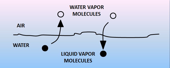
Clouds form when the atmosphere is saturated. Saturation occurs when the air holds the maximum amount of water vapor possible. At saturation the temperature is equal to the dew point temperature (T = Td); the vapor pressure is equal to the saturation vapor pressure (e = es); and the relative humidity is 100%. Saturation is a state of equilibrium. The graphic below shows that water is constantly evaporating and condensing. The amount of water vapor molecules in the air is constant, but the actual molecules are constantly changing their state (or phase).
Cloud Condensation Nuclei (CCN)
Now that we have water vapor and can reach the temperature for a droplet to become saturated, we need something for the water vapor to condensate to. This is where the dirt and the salt in the air play a significant part.
CCN are particles on which water vapor condenses to form water droplets. The most effective are hygroscopic (water attracting), and water-soluble. If the CCN are water soluble, the resulting water droplet is not pure water, but a solution. The concentration of the solution (mass of CCN to volume of
water in the droplet) depends upon the size of the CCN and the amount of vapor, which has condensed on to it (i.e., the volume of the droplet).

Initiation and Growth of Cloud Droplets
Cloud droplets are initiated by the condensation of water vapor on CCN. The figure below shows how cloud droplets continue to grow by water vapor condensing onto the droplet.
The Amount of Growth by Condensation
This is governed by the difference in saturation vapor pressures (es) between the droplet and its surrounding environment. The air immediately surrounding all the droplets is said to be saturated (e = es).

Each droplet will have a different es based upon its concentration. This is called the solute effect. Droplets consisting of higher concentrations of solution will have a lower es than more pure droplets. Conversely, droplets consisting of lower concentrations of solution will have a higher es than
less pure droplets.
The more water vapor a droplet has the higher the vapor pressure. Flow is from high pressure towards low pressure, so if two droplets of the same size but different purities exist side by side in a cloud, water vapor will evaporate from the more pure droplet (higher pressure), and condense onto the less pure droplet (lower pressure). In this way, the more pure droplet will shrink, and the less pure droplet will grow.
Droplets that are smaller or more tightly curved, will have a higher es than a larger droplet which will have a flatter surface. This is called the curvature effect. Droplets that are larger will grow at the expense of the smaller droplet, so the smaller droplet will shrink due to evaporation and the larger droplet will grow due to condensation.
Collision and Coalescence
Once droplets grow large enough to fall they can collide with other droplets, and merge to form even larger droplets. Coalescence means the droplets, which collide with each other, will stick together. This is the most efficient method of droplet growth (much more efficient than condensation). While this process is occurring the droplets are grow by condensation.
Different conditions affect the efficiency of the collision-coalescence process.
Temperature’s role
Having water attracting nuclei is not enough for a cloud to form as the air temperature needs to be below the saturation point. Called the dew point temperature, the point of saturation is where evaporation equals condensation.
Therefore, a cloud results when a block of air (called a parcel) containing water vapor has cooled below the point of saturation. Air can reach the point of saturation in a number of ways. The most common way is through lifting of air from the surface up into the atmosphere.
As a bubble of air, called a parcel, rises it moves into lower pressure since pressure decreases with height. The result is the parcel expands in size as it rises. This requires heat energy to be removed from the parcel. Called an adiabatic process, as air rises and expands it cools.

The rate at which the parcel cools with increasing elevation is called the “lapse rate”. The lapse rate (the rate the temperature lapses or decreases) of unsaturated air (air with relative humidity <100%) is 5.5°F per 1000 feet (9.8°C per kilometer). Called the dry lapse rate, for each 1000 feet increase in elevation, the air temperature will decrease 5.5°F.
Once the parcel reaches saturation temperature (100% relative humidity) water vapor will condense onto the cloud condensation nuclei resulting in the formation of a cloud droplet.
But the atmosphere is in constant motion. As air rises drier air is added (entrained) into the rising parcel so both condensation and evaporation are continually occurring. So, cloud droplets are constantly forming and dissipating.
Therefore, clouds form and grow when there is more condensation on nuclei than evaporation from nuclei. Conversely, they dissipate if there is more evaporation than condensation. Thus, clouds appear and disappear as well as constantly change shape.
Factors Affecting Efficiency
The first factor is residence time in the cloud. The longer the droplet remains in the cloud the greater chance it has to interact with other droplets. Thick clouds provide a greater distance for the droplet to fall. Updrafts within the cloud can bring droplets to upper portions of the cloud.
Droplets falling at different velocities is the second factor. If droplets are falling at different rates, the faster ones will catch up and collide with the slower ones. Larger droplets fall at a faster rate than smaller ones. A wide spectrum of sizes is indicative of variable fall velocities.
Precipitation size is another factor that affects collision and coalescence. Once the droplets grow large enough to fall to the ground, particles grow by this process also.

Initiation and Growth of Ice Crystals
Ice Nuclei (IN). These (similar to CCN) are necessary for liquid or vapor to form ice crystals. Typical natural IN is clay particles.
Silver iodide (AgI) is used as an artificial IN in cloud seeding operations.
Water droplets at temperatures below 0° C are called supercooled. They exist in the liquid state. If they encounter an ice crystal, they will automatically freeze. Supercooled water droplets are very common at temperatures above -10°C.
If no IN are present in the air, water will instantaneously freeze (form ice) when temperatures reach -40°C (-40°F) or below.
Once a crystal is formed, it grows by deposition (conversion of vapor to ice). The saturation vapor pressure over ice is less than that over water (esi<esw). Ice crystals will grow at the expense of water droplets.

Once the crystal grows large enough, it undergoes a process similar to collision-coalescence. The crystal can collide with cloud droplets. If the cloud is colder than 0°C, the droplets will freeze on contact. The crystal can also collide with other ice crystals. This process is responsible for the formation of large snowflakes.

Types of clouds
Stratiform Clouds
Stratiform clouds may consist of water droplets and/or ice crystals and persist for great periods of time. Stratiform cloud droplets are all nearly the same size (the same is true for the ice crystals in cold clouds) with small vertical velocities.
Cumuliform Clouds
Cumuliform clouds may consist of water and/or ice and are short lived. These clouds consist of droplets of varying sizes (same for ice crystals) with larger vertical velocities than stratiform clouds. Cumuliform clouds contain more liquid water than stratiform clouds (more is available to form precipitation). Larger vertical velocities increase residence time of droplets/ice crystals in the cloud, allowing water droplets to grow to larger sizes.
Topography and Clouds
Orographic Clouds
Orographic clouds form due to forced lift up a mountain and are stable clouds. Normally only the orographic barrier induces all vertical motion, and some convection may be embedded within the cloud.
Air is cooled adiabatically to its dew point and the cloud forms at the LCL (Lifting Condensation Level). As the air flows over the mountain, adiabatic warming occurs with the descent and the cloud dissipates on the leeside of the mountain barrier. Vertical velocities can be as large as several m/s depending on the speed and direction of the wind component perpendicular to the barrier, and the height of the barrier. In steady winds, these clouds can persist for long periods of time (up to days).
Lenticular Clouds
Lenticular clouds are stable clouds. Air flows over the mountains and waves form downstream. Air is forced up over the peak, but only rises so high due to the stable atmosphere, and as it descends, it does so only to a certain extent, again due to the stability.
Note: A stable atmosphere suppresses motion both upward and downward.
Air parcels are bouncing downstream. Clouds form in a lens shape. As the air ascends, it cools and a cloud forms (T = Td). As it descends the cloud dissipates. Can occur well downstream from the barrier. Also called standing wave or mountain wave clouds. Lenticular clouds are often middle-level clouds, but can be upper and even low-level clouds.
Lenticular clouds indicate turbulence. Disturbances in the flow across the mountains can be seen to altitudes of 30 km. Isolated mountain peaks produce disturbances up to 2 to 3 km above the peak, and lee waves do not persist very far downstream.
Rotor Clouds
Rotor clouds may form farther downstream. Near the surface, winds may switch directions, producing a rotation. This rotation produces a rotor cloud below the ACSL (Alto-Cumulus Standing Lenticular).
Shear Induced Wave Clouds (billow clouds)
Billow clouds are caused by vertical wind shear (rather than an orographic barrier) and are mid- and high-level clouds. They are oriented perpendicular to the wind shear.
Layered Clouds
Layered clouds are due to widespread ascent of air and are associated with development of cyclones.
Cold Front. Warm moist air forced upward causes a line of cumuliform clouds.
Region of Surface Low Pressure. Low-level convergence forms clouds.
Warm Fronts. Warm air rises up over colder air at the surface. (stable cloud form) stratus, altostratus and cirrostratus normally form under these conditions. These clouds can transition into cumuliform clouds (Sc, Ac, Cc). Bases are warmed by radiation from the surface. Tops are radiationally cooled. Reduces the stability of the air, small convective cells form in the stratiform clouds (rising air in the center, subsidence around the sides).
Convective Clouds (Cumulus Clouds). They form from surface heating (either due to solar heating of the surface or colder air moving over a warmer surface). Air motion is downward on the outside of the cloud. Sinking air due to convective circulation – cooler air slowly descends to replace the warm rising air.
Dry air entrainment
This causes dry air on the outside of the cloud to mix with the cloud. The edges of the cloud will appear sharp because of this. Heat loss due to evaporational cooling causes subsidence, making the air parcels heavier, so they sink. Vertical extent (thickness of cloud) depends on atmospheric stability and moisture content of the air. Convective clouds form at the CCL.
Fog
Fog is a cloud with its base at the earth’s surface. (Detailed information about forecasting fog formation is covered in Block VI.) Consists of small droplets suspended in the air. Stable cloud (small vertical velocities).
Types of Fog
- Radiation fog is due to radiational cooling of the earth’s surface. Air near the ground is cooled to its dew-point temperature by conduction. Gradual mixing transports cooling effects to reach higher levels.
- Valley fog occurs as cooler air drains downhill into a valley.
- Advection fog forms when warm moist air moves over a cold surface (i.e., coastal fog).
- Upslope fog is formed when air is cooled to its dew point as it moves up a barrier (similar to formation of orographic clouds).
- Evaporation fog occurs when cold air over a moisture source (i.e., steam fog occurs with cold air moving over warm water).
- Frontal fog occurs when warm rain falls through cold air and evaporates until the air becomes saturated.
Dissipation of Clouds
Evaporation of water droplets and sublimation of ice crystals. Ways to Dissipate Clouds. The first way is to decrease moisture. It “rains itself out”, or dry air entrainment. The second way is to increase air temperature through adiabatic warming, or warming from below (stable atmosphere).
Recent Posts
Determining Severe Weather Based On Stability Indexes and Upper-Level Winds
There are several weather products used to determine the possibility of severe weather for an area. The most common and misunderstood by many weather enthusiasts is the Skew-T chart and the upper-air...
Tornado Basics, Severe Weather Preparation, & The Enhanced Fujita scale
Earth's weather can produce various kinds of windstorms which include waterspouts, dust devils and tornadoes. Although they have the common features of a column of rotating air, they are actually...