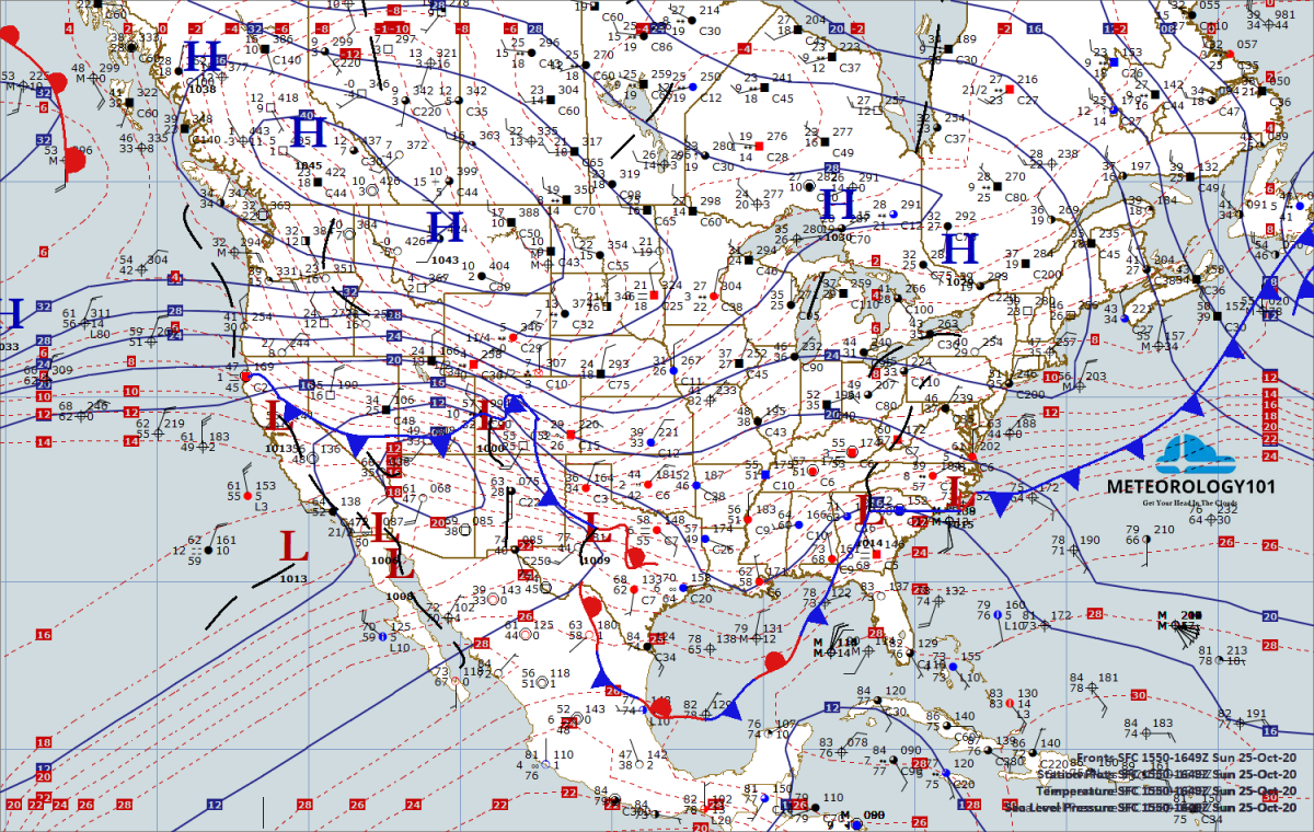
This article will discuss forecasting techniques using synoptic feature to determine cloud bases and tops as well as the associated weather with the types of frontal systems.
Frontal Cloud/Precipitation Relationships
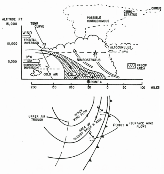
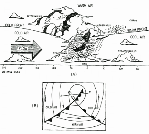
Active Cold Fronts
Basic Facts. Active cold fronts are slow moving fronts with an average speed 10-15kts. They are considered active because widespread (synoptic scale) clouds and precipitation occur at and behind the front due to actual frontal lifting. The average slope is approximately 1:100 miles. Parallel flow will exist at 700mb.
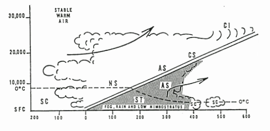
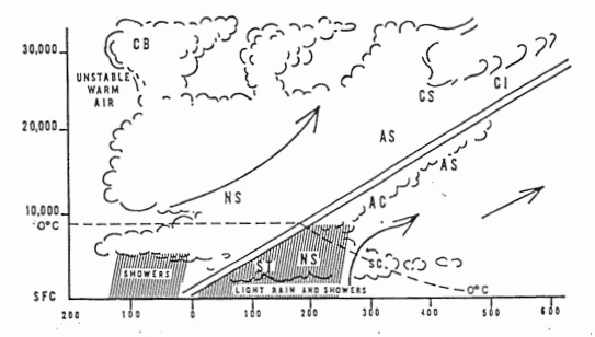
Associated Cloud Types. This is dependent on the stability of the warm air mass. If the warm air mass is stable, a broad zone of altostratus and nimbostratus clouds will accompany the front and extend several hundred miles behind. If the warm air is unstable (or conditionally unstable), Thunderstorms and cumulonimbus clouds may develop within the cloud bank and stretch some 50 miles behind the surface front. The CB’s form in the warm air. In the cold air, some stratus or nimbostratus may form from the evaporation of falling rain; though, relatively few clouds are found outside of rain areas. This is due to the descending motion of the cold air which sometimes produces a subsidence inversion behind the front.
Associated Weather/Precipitation. Also dependent on the stability (or perhaps more importantly cloud type) and moisture conditions of the air masses. Naturally, showers will occur when conditions are unstable (cumuliform clouds)and steady precipitation will occur when they are stable (stratiform). Visibility is poor in precipitation and may remain so for many hours after frontal passage (FROPA) as long as precipitation persists. When the cold air mass is moist and stable, a deck of stratus/fog may persist for hours after FROPA.
Inactive Cold Fronts
Basic Facts. Inactive cold fronts are fast moving fronts with an average speed of 25-30kts. They are considered inactive because lifting occurs at and ahead of the front. This lifting is caused by cold air descending ahead of the front causing low level convergence with the warm air. The average slope is approximately 1:40-1:80 miles. Perpendicular (within 45° of normal) flow exists at 700mb.
Associated Cloud Types And Weather. When the warm air mass is stable, an overcast layer of altostratus clouds and rain may extend over a large area ahead of the front. If the warm air is dry, little or no cloudiness will be associated with the front. If the warm air is moist and unstable, a line of thunderstorms frequently develops along and just ahead of the front. Stratus, nimbostratus, and altostratus may extend as much as 150 miles in advance of the cumulonimbus.
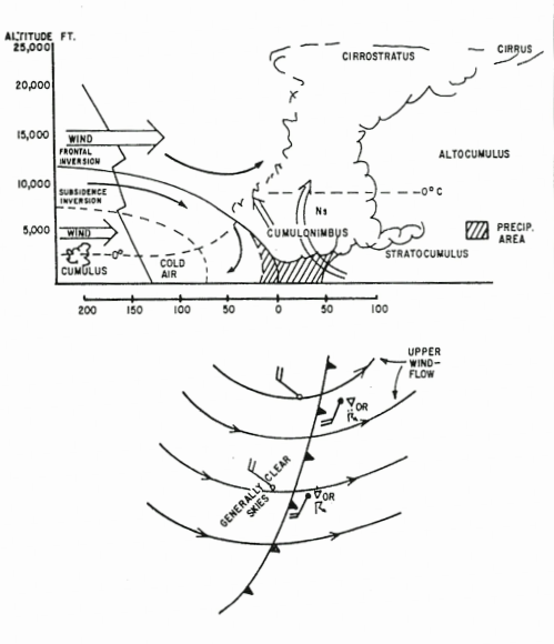
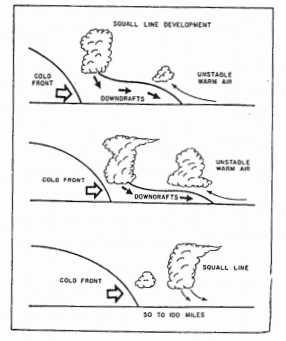
Sometimes a parallel line of strong convective activity is projected 50 to 200 miles ahead of the front forming a squall line. If the squall line is far enough in advance of the front, strong pressure rises, wind shifts, and temperature falls (associated with evaporational cooling due to falling precipitation) will likely occur with passage. However, winds will again become southerly, pressures will level off, and temperatures will become consistent with the warm air mass prior to FROPA.
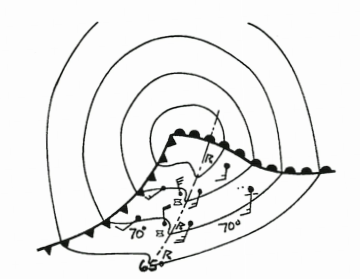
Dewpoints and wind direction are good indicators of passage of the actual cold front. Dew points drop rapidly after FROPA. Winds veer and are strong, gusty, and turbulent for a considerable time after passage. Generally speaking, unless the cold air is unstable and descending currents weak, few clouds will exist in the cold air behind the front.
Warm Fronts
Basic Facts. Warm fronts move at an average speed of 10-20kts. They exhibit characteristically shallow slopes due to the effects of friction which retards frontal movement at the surface. The average slope is between 1:100 and 1:300 miles. The typical sequence of cloud formations is as follows: cirrus, cirrostratus, altostratus, nimbostratus, and stratus. Cirrus may precede the front by 700 to 1000 miles or more. This is followed by cirrostratus found at about 600 miles in advance of the front. Cirrostratus is followed by altostratus which is found about 500 miles in advance of the front.
Associated Cloud Types And Weather. This varies with the characteristics of the air masses involved and whether the front is active or inactive.
A warm front is classified as active when the perpendicular wind component increases with height. This produces strong overrunning and pronounced prefrontal clouds and precipitation.
A warm front is classified inactive when the perpendicular wind component decreases with height. Inactive warm fronts are characterized by broken cirrus and altocumulus.
When the overrunning warm air is moist and stable, nimbostratus clouds and continuous (or intermittent) light to moderate precipitation are found approximately 300 miles ahead of the front. The type of precipitation (liquid vs. frozen) is dependent on the temperature of the cold air mass and the height of the freezing level. Ceilings lower rapidly as additional clouds form in the cold air under the frontal surface (evaporational cooling due to falling precipitation). If the cold air is stable, these clouds will be stratiform; if unstable, expect stratocumulus.
When the overrunning air is moist and unstable, cumulonimbus clouds are frequently imbedded in the nimbostratus and altostratus. In such cases, thunderstorms and showers occur along with continuous precipitation types. When the overrunning air is dry, it must ascend to higher altitudes before condensation occurs. In such cases, only high and middle clouds are observed.
Clearing usually occurs after passage of both stable and unstable fronts. Stratocumulus may be present in the warm air. Cumulonimbus may be present in the warm air in summer with an unstable front (air mass thunderstorms).
Occluded Fronts
Occlusions are formed when a cold front overtakes a warm front resulting in one of the fronts being displaced upward. As a result, warm air between the cold and warm front is shut off (lifted). Since occlusions are a combination of cold and warm fronts, the resulting weather is that of the cold front’s narrow band of violent weather and the warm front’s widespread area of cloudiness and precipitation. There are two types. Warm occlusions, and cold occlusions.
Cold Occlusions. This type of occlusion occurs when the cold air in advance of the warm front is warmer than the cold air behind the cold front. Since the air associated with the cold front is more dense, it undercuts the cool air ahead of the warm front forcing the warm front aloft.
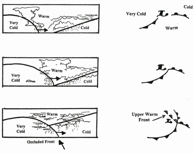
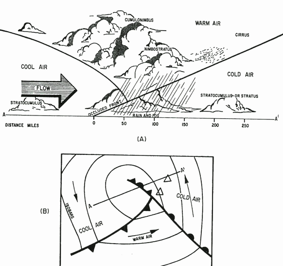
In the cold occlusion, the displaced upper warm front follows the surface occluded front by 20 to 50 miles. During the initial stages of development, the clouds and weather ahead of the occlusion are similar to that with associated with warm fronts; however, at the surface it is similar to that of cold fronts. Most precipitation occurs just ahead of the occlusion. The most violent weather occurs at the apex (or triple point) of the occlusion. Behind the occlusion clearing is usually rapid, especially if it is in the advanced stages. In the initial stages, clearing may not occur until passage of the upper front.
Warm Occlusions. This type of occlusion forms when the cold air in advance of the warm front is colder than the air behind the cold front. When the air of the cold front overtakes the warm front, it moves up over the colder air to form an upper cold front.
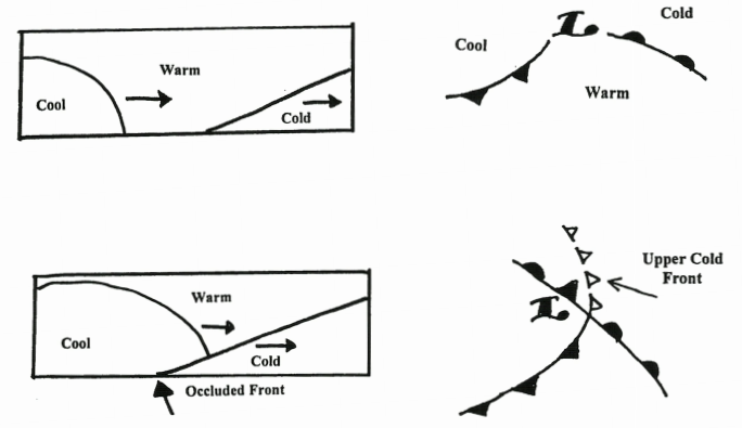
With a warm occlusion, the upper cold front precedes the surface occlusion by as much as 200 miles. The cloud sequence ahead of the occlusion is similar to that ahead of a warm front. If either the warm or cool air that is lifted is moist and unstable, showers and sometimes thunderstorms may develop. When this occurs the convective activity will be found just ahead of the upper cold front. The intensity of the weather occurring with the upper front decreases with distance from the occlusions apex (triple point). Weather conditions associated with occlusions change rapidly and are usually most severe in the initial stages. As the warm air is lifted to higher levels, clouds and weather diminish.
Quasi-stationary Fronts (a.k.a. Stationary Fronts)
Definition. A quasi-stationary front is a front along which one air mass is not appreciably replacing another air mass. The term “stationary” is actually a misnomer since it would be unusual for two air masses of different properties to be side by side without at least some movement. Most likely the front-is made up of a series of small waves undulating back and forth; hence the term “quasi”-stationary. Fronts moving less than 5 knots are usually classified as stationary.
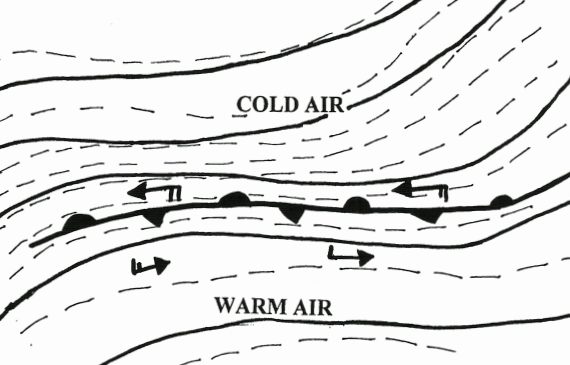
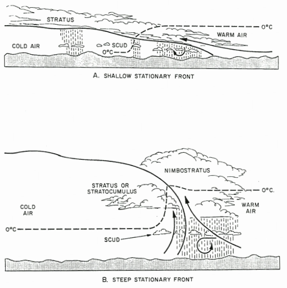
Characteristics. When a front is stationary, the cold air mass doesn’t move either toward or away from the front. This means the winds above the friction layer blow parallel to the front. Wind shifts across the front are usually near 180°. Isobars will nearly parallel a stationary front, making recognition on a surface chart easy. Frictional inflow of warm air toward the front causes a slow upglide of air on the frontal surface. As this air is lifted, saturation occurs and clouds form above the front. The width of the band of precipitation and low ceilings varies from 50 to about 200 miles depending upon the slope of the front and the temperatures of the air masses.
Stable Stationary Fronts. If the warm air is stable and the slope shallow, stratiform clouds will form. Drizzle may fall, and as the air is lifted above the freezing level, icing conditions develop and light rain or snow may fall. If the slope is steep and significant warm air is advected up the frontal surface, stratiform clouds with embedded showers are the result. Slight undulation or movement of the front toward the warm air mass will intensify the activity.
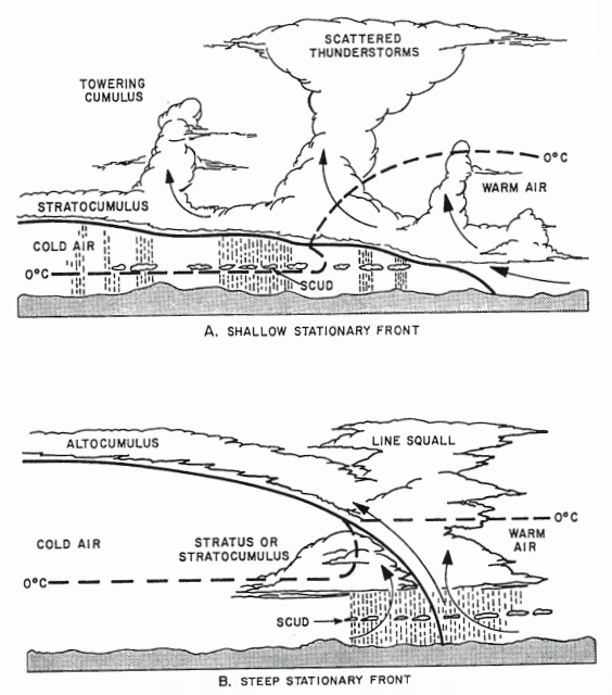
Unstable Stationary Fronts. If the warm air is conditionally unstable, the slope shallow, and sufficient lifting occurs, the clouds are then cumuliform or stratiform with embedded towering cumulus. If the energy release is great enough, thunderstorms result. The shallow slope results in a broad and extensive area of showers, fog, and reduced visibility. If the slope is steep and sufficient warm air is advected up the slope or the front moves slowly toward the warm air mass, violent weather can result. Heavy rain, severe thunderstorms, strong winds, and tornadoes can occur.
Recent Posts
Determining Severe Weather Based On Stability Indexes and Upper-Level Winds
There are several weather products used to determine the possibility of severe weather for an area. The most common and misunderstood by many weather enthusiasts is the Skew-T chart and the upper-air...
Tornado Basics, Severe Weather Preparation, & The Enhanced Fujita scale
Earth's weather can produce various kinds of windstorms which include waterspouts, dust devils and tornadoes. Although they have the common features of a column of rotating air, they are actually...

