
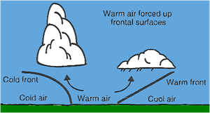
Forecasting cloud types is essential to determining precipitation amounts and intensities. The rule of thumb is the lower the cloud base, the higher the potential for precipitation intensity. Cumuliform clouds can grow to excess heights and are made up of much more moisture than stratiform clouds. Stratiform clouds are much thinner and produce steady precipitation. Don’t confuse rain intensity with rainfall amounts. Although stratiform clouds produce less intense rainfall, they can produce steady rain for long periods of time and therefore, much more rain amounts.
Cloud Types
Cirrus/Cirrostratus (high etage). These clouds can be very extensive in the horizontal but are relatively shallow vertically speaking. Common vertical extents average from 1,000 to 2,000ft. Ci or Cs may be present alone or together in layers.

Altocumulus/Altostratus (mid etage). These two cloud types can also be very extensive in the horizontal but the vertical extent of As averages from 1,000 to 2,000 ft. Ac tends to have a slightly greater vertical extent ranging on average from 1,000 to 5,000ft in depth.

Nimbostratus (mid to low etage). Very extensive in both the horizontal and vertical. The average vertical extent is from 10,000 to 20,000 ft. Nimbostratus typically lowers over time due to falling precipitation.
Stratus/Stratocumulus/Cumulus/Cumulonimbus (low etage). For cumuliform clouds, the stability of a region will dictate both the horizontal and vertical extent. St is a stable cloud type ranging from 1,000 to 4,000ft in vertical extent. St can at times be very extensive horizontally. Sc exists under stable conditions and is typically wider horizontally than deep vertically. The average vertical extent is between 1,000 and 4,000ft. Cu and Cb’s exist under unstable atmospheric conditions. The degree of instability dictates the extent of vertical development. The vertical extent can range from several thousand feet for Cu to 50,000ft or more for Cb’s.

Ceilings
Basic Nephanalysis Criteria. Areas with ceilings less than 1,000ft are enclosed using a solid red line. Ceilings greater than or equal to 1,000ft but less than 3,000ft; enclose in scalloped blue. Ceilings greater than or equal to 3,000ft but less than 10,000ft; enclose with scalloped purple. Greater than or equal to 10,000ft; depict in scalloped brown.

Label ceilings with the following information: Cloud amount in eighths (octas). This is immediately followed by the two letter cloud type (Sc, Cu, As, etc.). If two cloud types exist in conjunction or are layered, list both and separate with a solidus (“/”). Follow cloud type with the height of the cloud bases and tops indicated in three digits (10,000’s, 1,000’s, and 100’s). Bases go under tops and are separated by a line (for solid decks). When multiple decks exist and aren’t separated by an appreciable distance, substitute the line with the abbreviation “LYRD”.
Above all else Be Consistent!!! Don’t label a blue scalloped area (which is reserved for the low etage) as being Ac or As (these are mid etage cloud types).
Precipitation Areas
Clouds And Related Precipitation Types. Cu of strong vertical extent can and often does produce showery precipitation. Cb’s are pretty much synonymous with thunderstorms and produce showery precipitation. Sc, which is not the result of a stabilizing (Sc from Cu) situation, can produce light precipitation of a continuous or intermittent character. Any precipitation that falls from St is in the form of drizzle or snow grains (the exception to this would be if the St were underneath Ns).
Precipitation Area Depiction. Outline areas of continuous precipitation with a solid green line and indicate type and intensity with the appropriate symbol(s). Use an alternating dash/dot green line to depict showery precipitation types and again use appropriate symbol(s) for type and intensity. When two types of precipitation are forecast for the same area, list the predominate type first and separate by a solidus (“1”). Separate areas of liquid and frozen types with a solid green line. Depict areas of thunderstorms with an alternating dash/dot red line and, over the appropriate red thunderstorm symbol, indicate max top(s) using three digits in black.
Once again, consistency is a must! Don’t depict precipitation under cloud types that won’t produce precipitation (i.e., rainshowers under a Cs canopy). Likewise, don’t indicate rainshowers under strictly stable cloud types (i.e., rainshowers under Ns alone).
Recent Posts
Determining Severe Weather Based On Stability Indexes and Upper-Level Winds
There are several weather products used to determine the possibility of severe weather for an area. The most common and misunderstood by many weather enthusiasts is the Skew-T chart and the upper-air...
Tornado Basics, Severe Weather Preparation, & The Enhanced Fujita scale
Earth's weather can produce various kinds of windstorms which include waterspouts, dust devils and tornadoes. Although they have the common features of a column of rotating air, they are actually...