What is a Tropical Cyclone?
Tropical cyclones are among nature’s most powerful and destructive phenomena. If you live in an area prone to tropical cyclones, you need to be prepared. Even areas well away from the coastline can be threatened by destructive winds, tornadoes and flooding from these storms.
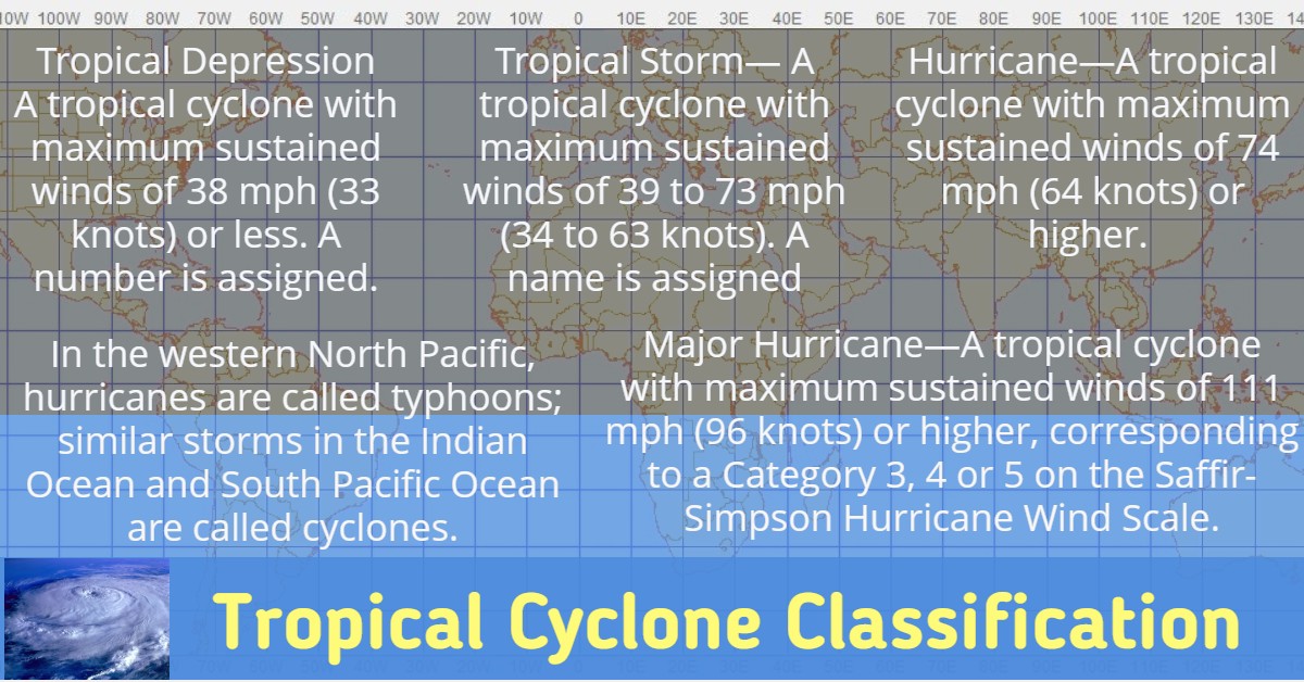
A tropical cyclone is a rotating, organized system of clouds and thunderstorms that originates over tropical or subtropical waters and has a closed low-level circulation. Tropical cyclones rotate counterclockwise in the Northern Hemisphere.

A Post-Tropical Cyclone is a system that no longer possesses sufficient tropical characteristics to be considered a tropical cyclone. Post-tropical cyclones can still bring heavy rain and high winds.
While hurricanes pose the greatest threat to life and property, tropical storms and depressions also can be devastating. Floods from heavy rains and severe weather, such as tornadoes, can cause extensive damage and loss of life. For example, Tropical Storm Allison produced over 40 inches of rain in the Houston area in 2001, causing about $5 billion in damage and taking the lives of 41 people.
Tropical cyclones forming between 5 and 30 degrees North latitude typically move toward the west. Sometimes the winds in the middle and upper levels of the atmosphere change and steer the cyclone toward
the north and northwest. When tropical cyclones reach latitudes near 30 degrees North, they often move northeast. Hurricane seasons and their peaks are as follows:
- Atlantic and Caribbean: Jun. 1 to Nov. 30 with peak mid-August to late October.
- Central Pacific (Hawaii): Jun. 1 to Nov. 30 with peak from July to September.
- East Pacific: May 15 to November 30
- Western North Pacific: Tropical cyclones can strike year round
Saffir-Simpson Hurricane Wind Scale
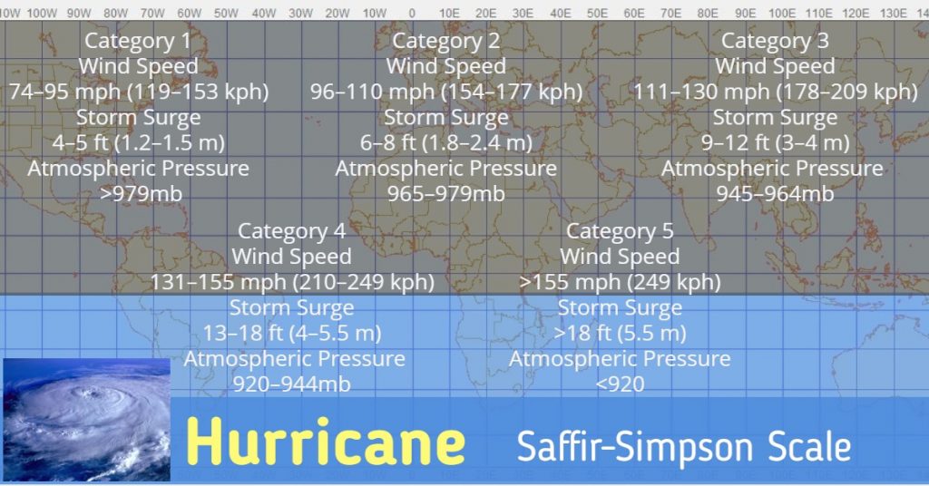
The Saffir-Simpson Hurricane Wind Scale is a 1 to 5 rating based on a hurricane’s sustained wind speed. This scale estimates potential property damage. Hurricanes reaching Category 3 and higher are considered major hurricanes because of their potential for significant loss of life and damage. Category 1 and 2 storms are still dangerous, however, and require preventative measures. In the western North Pacific, the term “super typhoon” is used for tropical cyclones with sustained winds exceeding 150 mph.
Hurricane Hazards
Storm Surge/Tide
Storm surge and large waves produced by hurricanes pose the greatest threat to life and property along the coast.
STORM SURGE is an abnormal rise of water generated by a storm’s winds. Storm surge can reach heights well over 20 feet and can span hundreds of miles of coastline. In the northern hemisphere, the highest surge values typically occur in the right front quadrant of a hurricane coincident with onshore flow; in the southern hemisphere, the left front quadrant. More intense and larger hurricanes produce higher surge. In addition, shallower offshore waters contribute to higher storm surge inundation. Storm surge is by far the greatest threat to life and property along the immediate coast.
STORM TIDE is the water level rise during a storm due to the combination of storm surge and the astronomical tide. For example, if a hurricane moves ashore at a high tide of 2 feet, a 15 foot surge would be added to the high tide, creating a storm tide of 17 feet. The combination of high winds and storm tide topped with battering waves can be deadly and cause tremendous property damage along an area of coastline hundreds of miles wide.
The destructive power of storm surge and large battering waves can result in loss of life, buildings destroyed, beach and dune erosion and road and bridge damage along the coast. Storm surge can travel several miles inland. In estuaries and bayous, salt water intrusion endangers public health and the environment.
Historical Storm Tide Events
- 1900: Galveston, TX, hurricane, resulted in more than 8,000 deaths, most by storm tide.
- 1969: Hurricane Camille produced a 24-foot storm tide in Mississippi.
- 1989: Hurricane Hugo generated a 20-foot storm tide in South Carolina.
- 1992: Hurricane Iniki produced a 6-foot storm tide on the island of Kauai in Hawaii.
- 2005: Hurricane Katrina generated a 27-foot storm tide in Mississippi.
- 2008: Hurricane Ike produced a 20-foot storm tide in Texas.
Tornadoes
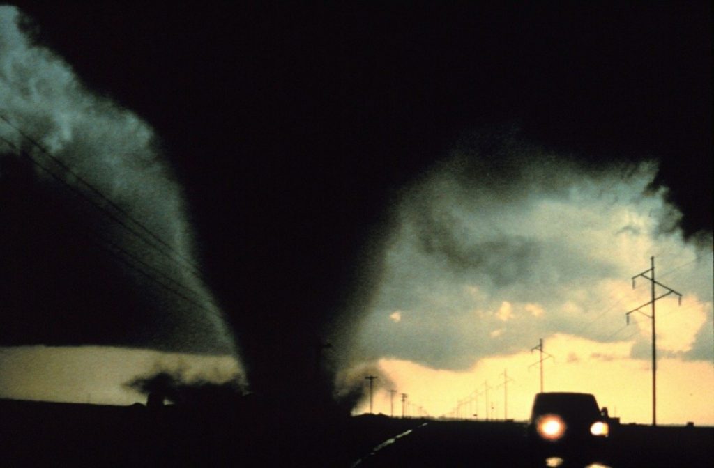
Hurricanes and tropical storms can also produce tornadoes. These tornadoes most often occur in thunderstorms embedded in rain bands well away from the center of the hurricane; however, they can also occur near the eyewall. Usually, tornadoes produced by tropical cyclones are relatively weak and short-lived, but they still pose a significant threat.
Winds
Hurricane-force winds, 74 mph or more, can destroy buildings and mobile homes. Debris, such as signs, roofing material, siding and small items left outside become flying missiles during hurricanes. Winds can stay above hurricane strength well inland. In 2004, Hurricane Charley made landfall at Punta Gorda on the southwest Florida coast and produced major damage well inland across central Florida with gusts of more than 100 mph.
Rainfall
Tropical cyclones often produce widespread, torrential rains in excess of 6 inches, which may result in deadly and destructive floods. In fact, flooding is the major threat from tropical cyclones for people living inland. Flash flooding, defined as a rapid rise in water levels, can occur quickly due to intense rainfall. Longer term flooding on rivers and streams can persist for several days after the storm.
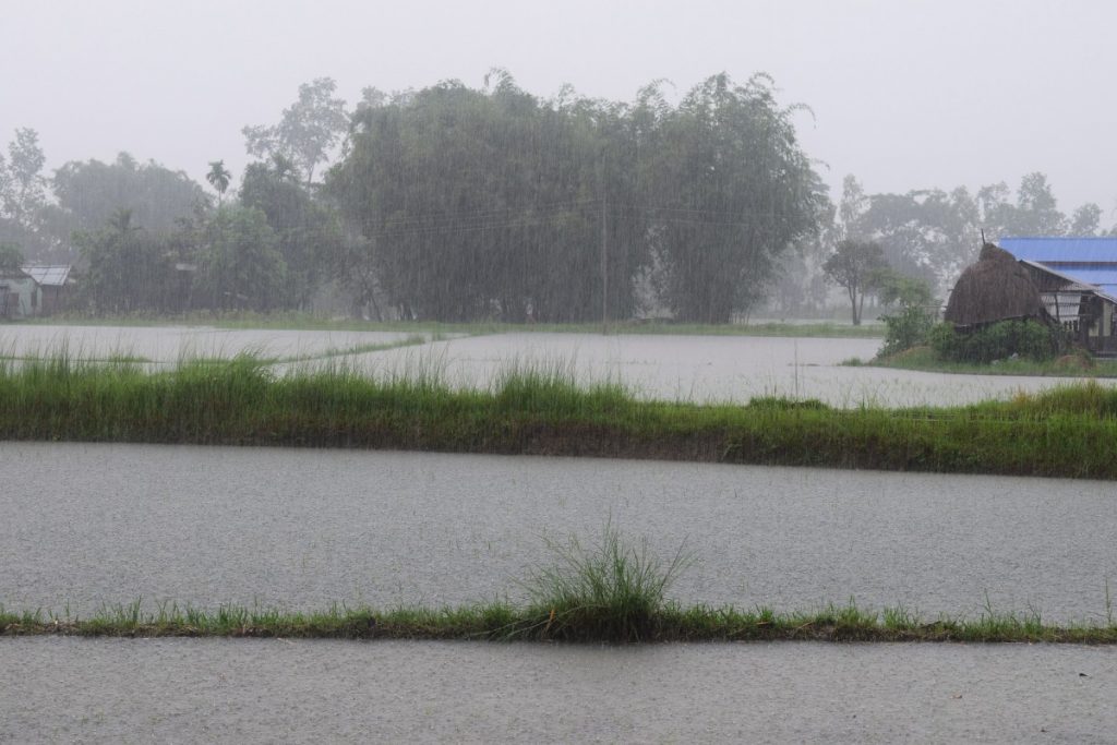
Rainfall amounts are not directly related to the strength of tropical cyclones but rather to the speed and size of the storm, as well as the geography of the area. Slower moving and larger storms produce more rainfall. In addition, mountainous terrain enhances rainfall from a tropical cyclone.
Rip Currents
The strong winds of a tropical cyclone can cause dangerous waves that pose a significant hazard to mariners and coastal residents and visitors. When the waves break along the coast, they can produce deadly rip currents—even at large distances from the storm.
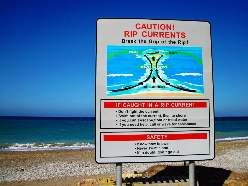
Rip currents are channeled currents of water flowing away from shore, usually extending past the line of breaking waves, that can pull even the strongest swimmers away from shore.

In 2008, despite the fact that Hurricane Bertha was more than a 1,000 miles offshore, the storm resulted in rip currents that killed three people along the New Jersey coast and required 1,500 lifeguard rescues in Ocean City, Maryland, over a 1 week period.
In 2009, all six deaths in the United States directly attributable to tropical cyclones occurred as the result of drowning from large waves or strong rip currents.
Tropical Cyclone Graphical Products
To convey analysis and forecast information on tropical cyclones, the National Hurricane Center (NHC) and the Central Pacific Hurricane Center (CPHC) produce graphics that provide important information for those who rely on tropical cyclone forecasts. Weather forecasting isn’t an exact science. Many of these graphics have been designed to address the inherent uncertainties in tropical cyclone forecasts.
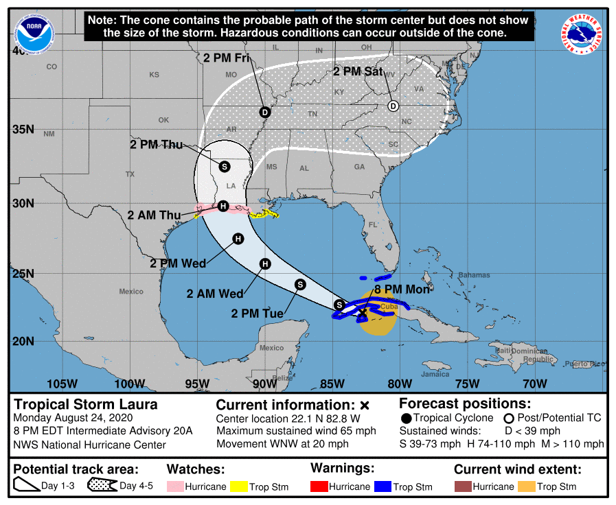
Track Forecast Cone and Watches/Warning
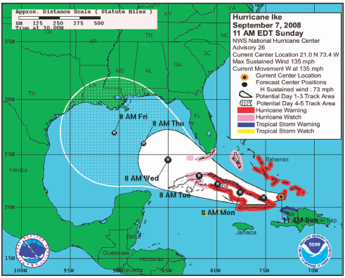
This graphic shows coastal areas under a hurricane warning (red), hurricane watch (pink), tropical storm warning (blue), and a tropical storm watch (yellow). The orange circle denotes the current position of the tropical cyclone. The black dots indicate the forecast positions and cyclone classification over the next 5 days.
Forecast errors and uncertainty of the future tropical cyclone center location are accounted for by the track forecast cone. The solid white area denotes the uncertainty for days 1-3. The white stippled area shows the uncertainty for days 4 and 5. On average, the center of the tropical cyclone will remain inside the cone 60%–70% of the time. It is important to remember that a tropical cyclone is not a point and that the associated hazards can extend well outside of the track forecast cone.
Graphical Tropical Weather Outlook
This graphic highlights areas of disturbed weather in the tropics and subtropics and assesses the potential for these systems to become tropical cyclones over the next 48 hours. Each disturbance is circled and numbered with an accompanying text description. You also can view the text description by moving your mouse over the circled area. The color of the circles reflect the probability that the system will become a tropical cyclone over the next 48 hours:
- Yellow: low chance, <30%
- Orange: medium chance, 30%–50%
- Red: high chance, >50%
Active tropical cyclones are depicted on the graphic as an “L” for tropical depressions, a tropical storm symbol, or a hurricane symbol.
Tropical Cyclone Surface Wind Speed Probabilities
This graphic indicates the chance of locations experiencing at least
tropical storm (39 mph or greater) sustained winds over the following 5 days. The graphic is also available at thresholds of 58 mph and 74 mph (hurricane force) sustained winds. The product is unique in that it takes into account uncertainty in the track, peak winds and size of the storm.
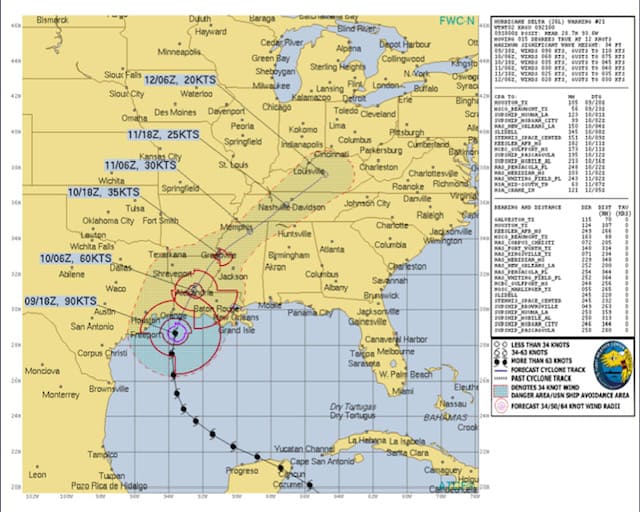
This graphic also highlights the fact that tropical cyclone winds can extend well away from the storm’s center. It is important to realize that probabilities that seem relatively low may still be quite significant. For example, if a location has a 10% chance of experiencing hurricane force sustained winds, you should prepare for an extreme event. A 1 in 10 chance is too high to ignore.
Tropical Cyclone Storm Surge Probabilities
Like surface wind speed probability products, storm surge probability products show the percentage chance of storm surge exceeding various thresholds. The thresholds are available at 1-foot intervals from a minimum of 2 feet to a maximum of 25 feet.
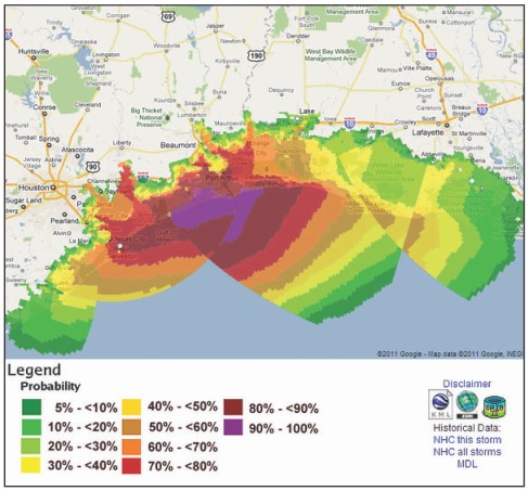
The graphic shows the chance that locations along the Texas and Louisiana coasts would experience a storm surge of at least 8 feet from Hurricane Ike based on the forecast issued at 11 AM EDT on September 12, 2008. The graphic is created from many simulations of the NWS storm surge computer model, and accounts for uncertainty in track, intensity and size.
Ways to Stay Informed
NOAA Weather Radio All Hazards
The National Weather Service (NWS) continuously broadcasts warning, watches, forecasts and non-weather related hazard information on NOAAWeather Radio All Hazards (NWR). The average range of the 1000+ NWR transmitters is 40 miles, depending on topography. For the best performing NWR receivers, NWS suggests you look at devices certified to Public Alert™ standards.
These radios meet specific technical standards and come with many features such as Specific Area Message Encoding (SAME), a battery backup, both audio and visual alarms, selective programming for the types of hazards you want to be warned for, and the ability to activate external alarm devices for people with disabilities. Similar to a smoke detector, an NWR can wake you up in the middle of the night to alert you of a dangerous situation.
Current Storm Information
| National Weather Service: www.weather.gov National Hurricane Center: www.nhc.noaa.gov Central Pacific Hurricane Center: www.prh.noaa.gov/cphc Mobile NWS smartphone websites: mobile.weather.gov National Climatic Data Center: www.ncdc.noaa.gov | Emergency/Preparedness Information American Red Cross: www.redcross.org FEMA: www.fema.gov Mobile NHC and NWS Information Mobile NHC website in basic HTML: www.nhc.noaa.gov/mobile |
Other Information
- Audio Podcasts: www.nhc.noaa.gov/audio/index.shtml
- Geographic Information System Data: www.nhc.noaa.gov/gis/
- NOAA Weather Radio All Hazards: www.weather.gov/nwr
- Hurricane Tracking Charts: www.weather.gov/os/hurricane/
- NHC Facebook Page: www.facebook.com/US.NOAA. NationalHurricaneCenter.gov
- CPHC/ NWS Honolulu Facebook Page: www.facebook.com/
- US.NationalWeatherService.Honolulu.gov
- Atlantic: @NHC_Atlantic
- Eastern North Pacific: @NHC_Pacific
- Central Pacific: @NWSHonolulu
- Storm Surge: @NHC_Surge
What To Listen For
- HURRICANE WATCH: An announcement that hurricane conditions (sustained winds of 74 mph or higher) are possible within the specified area in association with a tropical, subtropical, or post- tropical cyclone. Because hurricane preparedness activities become difficult once winds reach tropical storm force, the hurricane watch is issued 48 hours in advance of the anticipated onset of tropical-storm-force winds. During a Watch, prepare your home and review your plan for evacuation in case warnings are issued. Listen closely to instructions from local officials.
- TROPICAL STORM WATCH: An announcement that tropical storm conditions (sustained winds of 39 to 73 mph) are possible within the specified area within 48 hours in association with a tropical, subtropical, or post-tropical cyclone. During a Watch, prepare your home and review your plan for evacuations in case warnings are issued. Listen closely to instructions from local officials.
- HURRICANE WARNING: An announcement that hurricane conditions (sustained winds of 74 mph or higher) are expected somewhere within the specified area in association with a tropical, subtropical, or post-tropical cyclone. Because hurricane preparedness activities become difficult once winds reach tropical storm force, the hurricane warning is issued 36 hours in advance of the anticipated onset of tropical-storm-force winds. The warning can remain in effect when dangerously high water or a combination of dangerously high water and waves continue, even though winds may be less than hurricane force.
- TROPICAL STORM WARNING: An announcement that tropical storm conditions (sustained winds of 39 to 73 mph) are expected somewhere within the specified area within 36 hours in association with a tropical, subtropical, or post-tropical cyclone.
- EXTREME WIND WARNING: Extreme sustained winds of a major hurricane (115 mph or greater), usually associated with the eyewall, are expected to begin within an hour. Take immediate shelter in the interior portion of a well-built structure.
Additional Watches and Warnings are issued to provide detailed information on specific threats such as floods and tornadoes. Local National Weather Service offices issue Flash Flood/Flood Watches and Warnings as well as Tornado Warnings.
National Hurricane Center and Central Pacific Hurricane Center Products
PUBLIC ADVISORIES offer critical hurricane watch, warning and forecast information.
FORECASTS/ADVISORIES provide detailed hurricane track and wind field information
PROBABILITIES OF HURRICANE/TROPICAL STORM CONDITIONS offer locally specific chances of experiencing tropical storm, strong tropical storm and hurricane force winds out to 5 days to better know if one will be impacted and when these conditions may occur.
Local National Weather Service Office Products
HURRICANE LOCAL STATEMENTS give greater detail on how the storm will impact your area.
NON-PRECIPITATION WEATHER PRODUCTS provide High Wind Watches and Warnings for inland areas that could experience strong winds.
Use all of the above information to make an informed decision on your risk and what actions to take. Listen to recommendations of local officials on TV, radio and other media and to NOAA Weather Radio All Hazards for the latest tropical cyclone information.
Are You Ready?
Before the Hurricane Season
- Determine safe evacuation routes inland.
- Learn locations of official shelters.
- Check emergency equipment, such as flashlights, generators and battery-powered equipment such as cell phones and your NOAAWeather Radio All Hazards receiver.
- Buy food that will keep and store drinking water.
- Buy plywood or other material to protect your home if you don’t already have it.
- Trim trees and shrubbery so branches don’t fly into your home.
- Clear clogged rain gutters and downspouts.
- Decide where to move your boat.
- Review your insurance policy.
- Find pet-friendly hotels on your evacuation route.
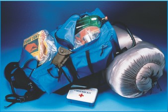
Sportsman 400 First Aid Kit By Tender Corporation/adventure Medical Kits
During the Storm
When in a Watch Area…
- Frequently listen to radio, TV or NOAA Weather Radio All Hazards for official bulletins of the storm’s progress.
- Fuel and service family vehicles.
- Inspect and secure mobile home tie downs.
- Ensure you have extra cash on hand.
- Prepare to cover all windows and doors with shutters or other shielding materials.
- Check batteries and stock up on canned food, first aid supplies, drinking water and medications.
- Bring in light-weight objects such as garbage cans, garden tools, toys and lawn furniture.
When in a Warning Area…
- Closely monitor radio, TV or NOAA Weather Radio All Hazards for official bulletins.
- Close storm shutters.
- Follow instructions issued by local officials. Leave immediately if ordered!
- Stay with friends or relatives at a low-rise inland hotel or at a designated public shelter outside the flood zone.
- DO NOT stay in a mobile or manufactured home. Notify neighbors and a family member outside of the warned area of your evacuation plans.
- Take pets with you if possible, but remember, most public shelters do not allow pets other than those used by used by people with disabilities. Identify pet-friendly hotels along your evacuation route.
Plan to Leave if You…
- Live in a mobile home. They are unsafe in high winds no matter how well fastened to the ground.
- Live on the coastline, an offshore island or near a river or a flood plain.
- Live in a high rise building. Hurricane winds are stronger at higher elevations.
If Staying in a Home…
- Turn refrigerator to maximum cold and keep it closed.
- Turn off utilities if told to do so by authorities.
- Turn off propane tanks.
- Unplug small appliances.
- Fill bathtub and large containers with water in case clean tap water is unavailable. Use water in bathtubs for cleaning and flushing only. Do NOT drink it.
If Winds Become Strong…
- Stay away from windows and doors, even if they are covered. Take refuge in a small interior room, closet or hallway.
- Close all interior doors. Secure and brace external doors.
- If you are in a two-story house, go to an interior first floor room.
- If you are in a multi-story building and away from water, go to the 1st or 2nd floor and stay in the halls or other interior rooms away from windows.
- Lie on the floor under a table or other sturdy object.
Be Alert For…
- Tornadoes—they are often spawned by hurricanes.
- The calm “eye” of the storm—it may seem like the storm is over, but after the eye passes, the winds will change direction and quickly return to hurricane force.
What to Bring to a Shelter
- First-aid kit
- Medicine, prescriptions
- Baby food and diapers
- Games, books, music players with headphones
- Toiletries
- Battery-powered radio and cell phone
- Flashlights
- Extra batteries
- A blanket or sleeping bag for each person
- Identification
- Copies of key papers such as insurance policies
- Cash, credit card
REMINDER: If you are told to leave your home, do so immediately!
After the Storm
- Keep listening to radio, TV or NOAA Weather Radio All Hazards.
- Wait until an area is declared safe before entering.
- Watch for closed roads. If you come upon a barricade or a flooded road, Turn Around!
- Stay on firm, dry ground. Moving water only 6 inches deep can sweep you off your feet.
- Standing water may be electrically charged from power lines.
- Never use a generator indoors.
- Avoid weakened bridges and washed out roads.
- Once home, check gas, water and electrical and appliances for damage.
- Use a flashlight to inspect damage. Never use candles and other open flames indoors.
- Wear proper shoes to prevent cutting feet on sharp debris.
- Do not drink or prepare food with tap water until officials say it is safe.
- Avoid electrocution by not walking in areas with downed power lines.
Family Emergency Plan
Everyone needs to be prepared for the unexpected. You, as well as your family and friends, will most likely not be together when disaster strikes. How will you find each other? Will you know if your children or parents are safe? You may have to evacuate or be confined to your home. What will you do if water, gas, electricity or phone services are shut off?
Steps to Take
Gather information about hazards
Contact your local National Weather Service office, emergency management office and American Red Cross chapter. Find out what type of emergencies could occur and how you should respond. Learn your community’s warning signals and evacuation plans. Assess your risks and identify ways to make your home and property more secure.
Meet with your family to create an emergency plan
Pick two places to meet: a spot outside your home for an emergency, such as fire, and a place away from your neighborhood in case you can’t return home. Choose an out of state friend as your family’s point of contact for everyone to call if the family gets separated. Discuss what you would do if advised to evacuate.
Implement your plan
- Post emergency telephone numbers by the phone.
- Install safety features in your house, such as smoke alarms and fire extinguishers.
- Inspect your home for items that can move, fall, break or catch fire and correct them.
- Have your family learn basic safety measures, such as CPR and first aid, how to use a fire extinguisher, and how and when to turn off water, gas and electricity in your home.
- Teach children how and when to call 911 or your local emergency number.
- Keep enough supplies in your home for at least 3 days. Assemble an emergency supplies kit. Store these supplies in sturdy, easy-to-carry containers, such as backpacks or duffle bags. Keep important documents in a waterproof container. Keep a smaller emergency supplies kit in the trunk of your car.
An Emergency Supplies Kit Should Include:
- At least a 3-day supply of water (one gallon per person, per day)
- At least a 3-day supply of non-perishable food
- At least, one change of clothing and shoes per person
- One blanket or sleeping bag per person
- First-aid kit
- Battery-powered NWR and a portable radio
- Emergency tools
- Flashlight, extra batteries
- Extra set of car keys
- Credit card and cash
- Special items for infant, elderly or disabled family members
- Prescription and non-prescription medicines
Practice and maintain your plan
Ensure your family knows meeting places, phone numbers and safety rules. Conduct drills. Test your smoke detectors and NWR monthly and change the batteries at least once each year. Test and recharge your fire extinguisher(s) according to manufacturer’s instructions. Replace stored water and food every 6 months.
Recent Posts
Determining Severe Weather Based On Stability Indexes and Upper-Level Winds
There are several weather products used to determine the possibility of severe weather for an area. The most common and misunderstood by many weather enthusiasts is the Skew-T chart and the upper-air...
Tornado Basics, Severe Weather Preparation, & The Enhanced Fujita scale
Earth's weather can produce various kinds of windstorms which include waterspouts, dust devils and tornadoes. Although they have the common features of a column of rotating air, they are actually...

