
The temperature contrast between air masses is the cause of the jet stream. Referring back to pressure gradient, it is the pressure differences that cause wind. The higher pressure flows towards lower pressure. Since cold air is more dense than warm air, there is a pressure difference between the two. The deeper the air masses are, the higher the altitude the larger the difference in pressure.
Different altitudes can experience different temperatures. There can be an increase in temperature with height and this will slow the wind speed. The altitude that has the greatest wind speed is considered the level of the jet stream.
The strongest wind speeds occur between the air masses with the greatest temperature differences and in the deepest layer of the troposphere. The wind are affected by the rotation of the earth called coriolis force and causes the wind direction to turn to the right in the northern hemisphere and to the left in the southern hemisphere.

Causes Of Jet Streams
Jet streams are caused by primarily two reasons. First, Large horizontal temperature contrast are associated with a large thermal wind vector. Second, the interaction between the Hadley and Farrell cells.

Jet streams that form by large horizontal temperature contrast (HTC) across the jet stream axis are at the tropopause because this is where contour gradient force is at a maximum. Above and below the tropopause the slope of a constant pressure surface weakens.

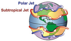
The other cause of jet streams, primarily the subtropical jet, is the interaction between the Hadley and Farrell cells. These two cells are located in the tropical and middle latitudes in both the northern and southern hemispheres. The convergence of winds in the upper altitudes of these two cells causes the subtropical jet to form.

Characteristics Of Jet Streams
Tropopause heights tend to change abruptly, and the tropopause tends to be discontinuous in two areas between the tropopause leaves and its height varies with the height of the tropopause leaves.There are three major types of tropopause leaves. First, the Polar leaf, it is lower and therefore warmer than the other leaves and is generally located poleward of 60° latitude, second is the Mid-Latitude leaf. It is generally located between 30° and 60° latitude in both hemispheres. Lastly is the Tropical leaf which is generally located equatorward of 30° latitude. It is higher and therefore colder than the other leaves.

The typical dimensions of a jet stream include a length in thousands of kilometers, and a depth of several kilometers.

Physical & Thermal Structure
The wind speeds within the jet core are relatively uniform. Since there is not much difference in speed, there is normally very little wind shear. If there had been a great amount of wind shear within the jet core, the aircraft during WWII may have been torn apart.

The jet axis is the axis of maximum wind speeds through the center of the jet core. Intermittent regions of the strongest wind speeds within the jet are called jet maxima (or jet maxes). The isotachs (lines of equal wind speed) which define the jet maximum are elliptically shaped both horizontally and vertically .

Isotach Gradients
In the horizontal, the isotach gradients are stronger on the cold air side (+n) of the jet maximum. In the vertical, the isotach gradients are strongest above (+z) the jet stream. The isotach gradient relationship described applies directly to the Polar Front Jet and to a lesser degree to the Sub Tropical Jet. Isotach gradient ranking from the strongest to the weakest are +z, -z +n, -n, +s/-s.

Wind Shear & Turbulence
Shear and turbulence associated with the jet stream are directly related to the strength of the isotach gradient and stability. Shear is the difference between the wind speed or direction per unit distance. With the jet stream shear is due mainly to the change in wind speed. Because of this, the greatest shear will be found where the isotach gradient is the strongest.
I think of wind shear as a busy highway moving at full speed and each car represents its own element of wind speed. As the cars pass each other at different speeds, the shear is the difference in speed between two cars. The greater the speed one car passes another, the greater the wind shear.
Vertical (the strongest) shear is stronger on the +z side of the jet core than on the -z side. Lateral (second strongest) shear is strongest on the +n side of the jet core than the -n side. Longitudinal shear is negligible in the +s/-s direction because there is no cross winds.
Jet stream turbulence is the shear produced by irregular motions within unstable air. Very strong shear is not sufficient by itself to produce severe turbulence, unstable air (thermal advection) is also required. Areas of strong temperature advection (baroclinicity) are high threat areas for turbulence. This turbulence at times is strong enough to cause structural damage to aircraft.


Specific Jet Streams
Polar Front Jet (PFJ)
The primary cause of the polar front jet is horizontal (north/south) temperature contrast. The polar front jet is located above and on the warm side of the polar leaf and below and on the cold air side of the mid-latitude leaf (recall the 3 leaf concept). This places the stratospheric air on the cold air side and above the jet, and tropospheric air on the warm side and below the jet.
The polar front jet migrates with the season and moves toward the equator in the winter and toward the poles in the summer. The continental polar air mass begins to move south out of its source region causing the temperature contrast between air masses to move with it. The height varies with the tropopause leaves and its relationship to a given constant pressure surface, 200mb and 300mb, will vary with the situation.
The jet maximum speeds also vary with seasons. They are stronger in the winter than in the summer, due to the stronger thermal gradient in the winter. The jet core heights will vary with the tropopause. They will be higher in the summer than in the winter due to higher temperatures, Virtual temperature (Tv), and therefore atmospheric thickness.
The reason for this is cold air is more dense than warm air and when it move to lower pressure, it moves much faster than the warm air could move in to replace cold air that has moved out

How To Identify The Polar Front Jet
The following “rule of thumb” will give you a general idea as to jet location and should be applied using seasonal and situational adjustments for accurate locations.
The PFJ is located above the tightest thickness packing on the 1000-500mb/thickness chart.The PFJ is generally found above the strongest 500mb contour gradient and wind flow. Often found between 5,500 & 5,670 meters, and averages around 5,600 meters.
The PFJ is generally found 350 nautical miles (6° of latitude) on the cold air side of the surface polar front. The actual location will vary greatly depending on the upper levels and heights of the air masses causing the jet.
The PFJ will be above the maximum thermal gradient (generally between -15° & -25°C) and on the average found near the -17°C isotherm on the 500mb chart. The PFJ will be located in the warm air above the cold air behind the surface polar front.
Cirrus loud decks tend to form or persist on the warm side of the jet stream axis, with a well defined cloud border along the axis. The cirrus will form at the base of the longwave trough axis and extend downstream to the longwave ridge axis. Some cloudiness may extend slightly beyond a low amplitude ridge axis.
Final positioning of the jet depends on the interpretation of the 200/300mb isotach analysis, 500mb contour gradient, thickness chart and satellite analysis. Typically the polar front jet will decrease in altitude in the winter and is signified by the height of the cirrus clouds. Speaking through experience on the desk, the cloud height are around 20,000 feet in the winter and 30,000 feet in the summer (observed in North America).

Formation Of The Subtropical Jet (STJ)
Two main factors contribute to the formation of the subtropical jet. First, the convergence between the Hadley and Farrell cells. Second, horizontal temperature contrast, the interaction of warm moist subtropical air and cold dry polar air. Location is generally between 25° and 35° latitude with a mean latitude of 28°. Conservation of angular momentum is a factor in accelerating the STJ.
AM = mvr
For a specific air parcel, if the mass (m) is constant and the radius (r) changes, velocity (v) must change so the angular momentum can be conserved. The radius in the formula is the distance from the earth’s axis to the surface. As the radius of rotation decreases, for a poleward moving parcel (from point A to B), the linear and angular velocity will increase. As the radius of rotation increases, for an equatorward moving parcel (from point B to C), the linear and angular velocity will decrease.
If you have ever spun a basketball on you finger, you would notice that the center of the ball appears to be spinning slower than the top or bottom of the ball. All parts of the ball is actually spinning at the same speed, since the atmosphere is not physically attached to the earth, the affect on the moving parcel changes at each location.
Coriolis force causes recurvature because as velocity increases, coriolis force increases and turns the jet to the right. Just like the PFJ, the STJ also has seasonal variances. The jet will be stronger in the winter than in the summer, typically weak during hurricane season.
Upper level wind shear will wreak havoc on a hurricane. If the subtropical jet stream hung out over Florida all summer, there would be no hurricane threats. However, the thunderstorms over Florida would most likely be more severe.
The STJ core is located between the mid-latitude and tropical tropopause leaves (approximately 150 – 200mb). Jet cirrus is commonly found on the warm side of the STJ axis, often forming traverse bands.

How To Identify The Subtropical Jet
The following “rule of thumb” will give you a general idea as to jet location and should be applied using seasonal and situational adjustments for accurate locations. The STJ will be found, on average, above the -11°C isotherm on the 500mb chart.
The subtropical jet is a result of the temperature contrast between the maritime tropical air mass and the colder air to the north.
Interaction Between The Sub Tropical And Polar Front Jets
Confluence between the STJ & PFJ cores results in favorable conditions for the development of severe thunderstorms just downstream of the jet max. Satellite imagery shows a characteristic wedge shaped cloud.
It is in this region of confluence where the STJ velocities are often the greatest. Partly because the STJ axis is at its furthest poleward extent and the radius of the earth is at its smallest. Also, the confluence with air already moving at high speeds in the PFJ results in producing a broader and stronger jet maximum.
The STJ is very important in transporting warm moist air poleward to interact with the cool dry polar air producing strong temperature, contour, and isotach gradients.
The STJ is generally located between 25° and 35° latitude, with a mean latitude of 28°. Jet cirrus is normally found on the warm air side in the form of transverse bands. The jet is normally located using the strongest wind band as analyzed on the 200mb chart.
Recent Posts
Determining Severe Weather Based On Stability Indexes and Upper-Level Winds
There are several weather products used to determine the possibility of severe weather for an area. The most common and misunderstood by many weather enthusiasts is the Skew-T chart and the upper-air...
Tornado Basics, Severe Weather Preparation, & The Enhanced Fujita scale
Earth's weather can produce various kinds of windstorms which include waterspouts, dust devils and tornadoes. Although they have the common features of a column of rotating air, they are actually...