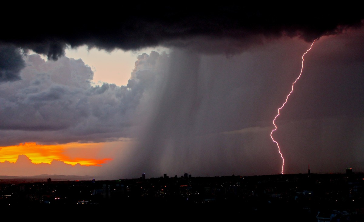
The conditions needed to produce lightning have been known for some time. However, exactly when and where lightning strikes is not predictable and likely never will be.
The generation of an electrical field within a thunderstorm is dependent on the size of the frozen precipitation within the storm. Types of frozen precipitation within a thunderstorm include: ice, hail, and semi-frozen water drops known as graupel. Storms that produce small quantities of ice, usually produce little to no lightning.
These ice formations are suspended in the air by the updraft of the storm and collide with water droplets and begin to grow. The stronger the updraft, the larger the hail it can produce. As the hail ascends and descends, the particles rub against each other and build up a static charge and eventually will become discharged with a lightning strike.

By educating yourself about lightning and learning some basic safety rules, you, your family, and your friends can avoid needless exposure to the dangers of one of the most capricious and unpredictable forces of nature.
Charge Separation
Thunderstorms have very turbulent environments. Strong updrafts and
downdrafts occur with regularity and within close proximity to each other. The updrafts transport small liquid water droplets from the lower regions of the storm to heights between 35,000 and 70,000 feet, miles above the freezing level.
Meanwhile, downdrafts transport hail and ice from the frozen upper regions of the storm. When these collide, the water droplets freeze and release heat. This heat in turn keeps the surface of the hail and ice slightly warmer than their surrounding environment, and a “soft hail”, or “graupel” forms.
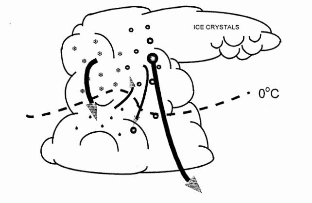
When this graupel collides with additional water droplets and ice particles, a critical phenomenon occurs: Electrons are sheared off of the ascending particles and collect on the descending particles. Because electrons carry a negative charge, the result is a storm cloud with a negatively charged base and a positively charged top.
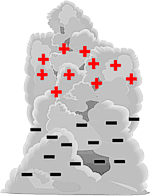
thunderstorm
Field Generation
In the world of electricity, opposites attract and insulators inhibit. As positive and negative charges begin to separate within the cloud, an electric field is generated between its top and base. Further separation of these charges into pools of positive and negative regions results in a strengthening of the electric field.
However, the atmosphere is a very good insulator that inhibits electric flow, so a TREMENDOUS amount of charge has to build up before lightning can occur. When that charge threshold is reached, the strength of the electric field overpowers the atmosphere’s insulating properties, and lightning results.
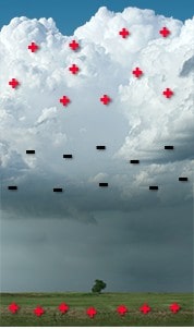
thunderstorm
The electric field within the storm is not the only one that develops. Below the negatively charged storm base, positive charge begins to pool within the surface of the earth.
This positive charge will shadow the storm wherever it goes, and is responsible for cloud-to-ground lightning. However, the electric field within the storm is much stronger than the one between the storm base and the earth’s surface, so most lightning (75-80%) occurs within the storm cloud itself.
How Lightning Develops Between The Cloud And The Ground
A moving thunderstorm gathers another pool of positively charged particles along the ground that travel with the storm.
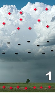
As the differences in charges continue to increase, positively charged particles rise up taller objects such as trees, houses, and telephone poles. A channel of negative charge, called a “stepped leader” will descend from the bottom of the storm toward the ground.
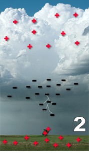
It is invisible to the human eye, and shoots to the ground in a series of rapid steps, each occurring in less time than it takes to blink your eye. As the negative leader approaches the ground, positive charge collects in the ground and in objects on the ground.
This positive charge “reaches” out to the approaching negative charge with its own channel, called a “streamer”. When these channels connect, the resulting electrical transfer is what we see as lightning. After the initial lightning stroke, if enough charge is leftover, additional lightning strokes will use the same channel and will give the bolt its flickering appearance.
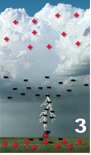
Tall objects such as trees and skyscrapers are commonly struck by lightning. Mountains also make good targets. The reason for this is their tops are closer to the base of the storm cloud.
Remember, the atmosphere is a good electrical insulator. The less distance the lightning has to burn through, the easier it is for it to strike.
However, this does not always mean tall objects will be struck. It all depends on where the charges accumulate. Lightning can strike the ground in an open field even if the tree line is nearby.
The Lightning Process
Lightning can be divided into two types:
- Flashes with at least one channel connecting the cloud to the ground, known as “cloud-to-ground” discharges (CG).
- Flashes with no channel to ground, known as “in-cloud” (IC), “cloud-to-cloud” (CC), or “cloud-to-air” (CA).
The lightning process is more or less the same for both types.
Step 1
A typical CG lightning strike initiates inside the storm. Under the influences of the electric field between the cloud and the ground, a very faint, negatively charged channel called a “stepped leader” emerges from the storm base and propagates toward the ground in a series of steps about 160 feet (50 meters) in length and 1 microsecond (0.000001 seconds) in duration.
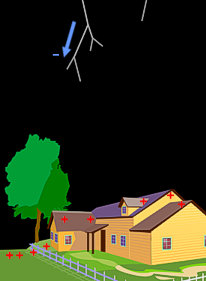
In what can be loosely described as an “avalanche of electrons”, the stepped leader usually branches out in many directions as it approaches the ground, carrying an EXTREMELY strong electric potential: about 100 MILLION volts with respect to the ground and about 5 coulombs of negative charge.
Between each step there is a pause of about 50 microseconds, during which the stepped leader “looks” around for an object to strike. If none is “seen”, it takes another step, and repeats the process until it “finds” a target.
It takes the stepped leader about 50 milliseconds (1/20th of a second) to reach its full length, though this number varies depending on the length of its path. Studies of individual strikes have shown that a single leader can be comprised of more than 10,000 steps!
Step 2
As the stepped leader approaches the ground, its strong, negative charge repels all negative charge within the immediate strike zone of the earth’s surface, while attracting vast amounts of positive charge. The influx of positive charge into the strike zone is so strong that the stepped leader actually induces electric channels up from the ground known as “streamers”.
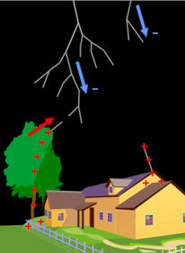
When one of these positively charged streamers connects with a negatively charged stepped leader (anywhere from 100 to 300 feet (30 to 100 meters) above the surface of the earth), the following steps occur in less than 100 microseconds.
Step 3
The electric potential of the stepped leader is connected to the ground and the negative charge starts flowing DOWN the established channel.
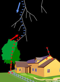
Step 4
An electric current wave, called a “return stroke”, then shoots UP the channel producing a brilliant pulse. It only takes the current about 1 microsecond to reach its peak value, which averages around 30,000 amperes.
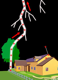
This “return stroke” is more than 99% of a lightning bolt’s luminosity and is what we see as lightning. The stroke actually travels FROM the ground INTO the cloud, but because the strike takes place so quickly, to the unaided eye is appears the opposite is true.
Step 5
An electric current wave, called a “return stroke”, shoots UP the channel as a brilliant pulse. Behind the wave front, electric charge flows up the channel and produces a ground current. It takes the current about 1 microsecond to reach its peak value, which averages around 30,000 amperes.
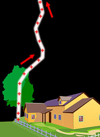
The “return stroke” produces more than 99% of a lightning bolt’s luminosity and is what we see as lightning. The stroke actually travels FROM the ground INTO the cloud, but because the strike takes place so quickly, to the unaided eye is appears the opposite is true.
After the return stroke ceases flowing up the channel, there is a pause of about 20 to 50 milliseconds. After that, if enough charge is still available within the cloud, another leader can propagate down to the ground. This leader is called a “dart leader” because it uses the channel already established by the stepped leader and therefore has a continuous path.
Dart leaders give lightning its flickering appearance and normally are not branched like the initial stepped leader. Not every lightning flash will produce a dart leader because a sufficient charge to initiate one must be available within about 100 milliseconds of the initial stepped leader.
The dart leader carries additional electric potential to the ground and induces a new streamer from the ground. The dart leader’s peak current is usually less than the initial stepped leader and its return stroke has a shorter duration than the initial return stroke. As additional dart leaders are produced, their peak currents and return stroke durations continue to decrease.
Dart leaders and their return strokes don’t necessarily have to use the same cloud-to-ground channel that was burned by initial stepped leader. If a dart leader takes a different path to the ground, the lightning will appear to dance from one spot to another. This is known as “forked lightning”.
The combination of each leader (stepped and dart) and their subsequent return strokes is known collectively as a “stroke”. All strokes that use the same channel constitute a single “flash”. A flash can be made up of a single stroke, or tens of strokes. (The highest number of strokes ever recorded in a single cloud-to-ground flash is 47!)
Notice, in the greatly slowed down animation , the top part of a lightning flash is not connected to anything physical in the cloud, as the cloud itself is not conductive. What happens is the lightning channel branches out inside the cloud in a tree-like shape, and draws free electrons to it (the negative charge in the lower half of the thunderstorm).
Recent Posts
Determining Severe Weather Based On Stability Indexes and Upper-Level Winds
There are several weather products used to determine the possibility of severe weather for an area. The most common and misunderstood by many weather enthusiasts is the Skew-T chart and the upper-air...
Tornado Basics, Severe Weather Preparation, & The Enhanced Fujita scale
Earth's weather can produce various kinds of windstorms which include waterspouts, dust devils and tornadoes. Although they have the common features of a column of rotating air, they are actually...

