
There are over fourteen million thunderstorms worldwide every year. Most thunderstorms are short-lived cells developed over land during daytime heating from the sun. Thunderstorm cells are developed from instability, available moisture and a lifting mechanism to trigger the development. The lower level of the troposphere becomes unstable from higher temperatures and increased water vapor in the air. Other thunderstorms form from the approach of an upper level disturbance or unusual cooling in which case they can form at any time of day or night without the aid of heating.
Moisture
Water comes in various forms when it comes to atmospheric studies and attention to moisture is very important for weather generation. For the development of thunderstorms adequate moisture is a must and is one of the thunderstorm building blocks. The process of cloud formation is explained in another article.
Moisture Source Regions
The obvious source of moisture are the oceans. For the United States, the sub-tropical highs off the east and west coasts bring plenty of moisture onshore for thunderstorms to develop. The less obvious sources are lakes and rivers. Surface heating can evaporate enough moisture and cause a heat low to produce enough lift to get the required instability for a thunderstorm to develop.
Higher levels moisture can be transported thousands of miles from the Pacific ocean into the southwest United States.
Instability
Since our layer of the atmosphere decreases in temperature with height and cold air is more dense than warm, the atmosphere is constantly trying to balance itself.

If an air parcel is given a boost upward and continues to rise or sink after it is nudged, it is considered to be unstable. Cold over warm is unstable and warm over cold is stable.
As an air parcel rises, it expands and cools. Once the parcel cools to the dew-point, it condensates on dust particles and becomes saturated becoming one of billions of droplets that form a cloud. These droplets continue to form and create a cumulonimbus clouds that is the thunderstorm cloud.
Lift
Lift is the mechanism that starts the upward motion required for thunderstorm development. Sources of lift include, frontal, mechanical and orographic. Some of these include fronts, the dry line in the southern U.S., mountain ranges and even outflow boundaries from other thunderstorms can cause enough lift to form another thunderstorm.

A thunderstorm cell ordinarily evolves through three stages: cumulus, mature, and dissipating. The stage of development that the thunderstorm reaches will determine the severity or intensity of the storm. There are several outside factors that will effect the development or dissipation of the storm.
There must be sufficient water vapor in order for the storm to form, since cloud and precipitation originates as water vapor. This is the fuel for the thunderstorm. As the storm uses this fuel, it is converted to rainfall. Eventually, the storm stabilizes the atmosphere by using up the excess water vapor and cooling the lower atmosphere, and warming the upper atmosphere.
As we go through each stage of development, we will see the characteristics associated with each level of development.
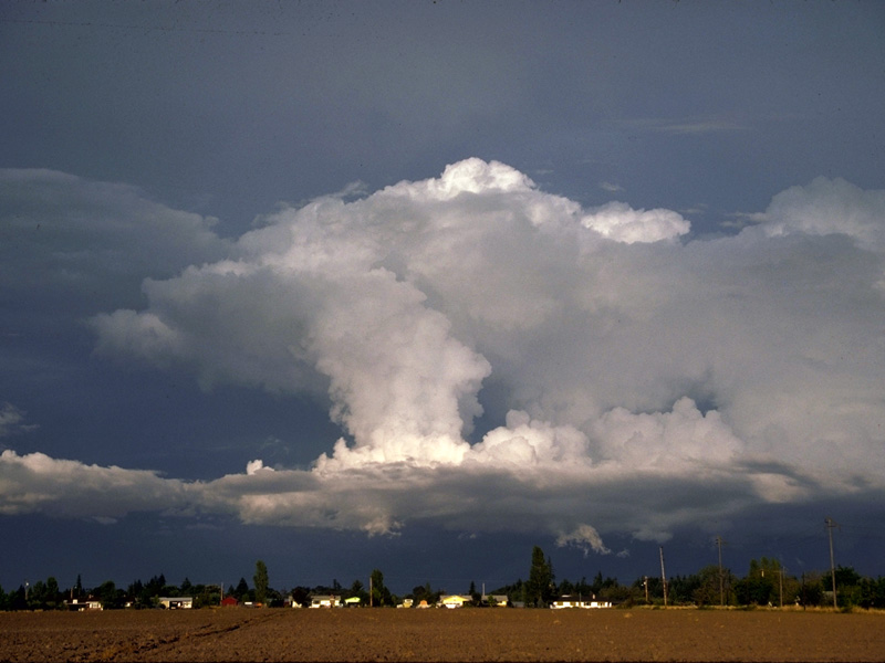
Cumulus Stage
This stage is marked by the formation of the first convective cloud. With its base at or slightly above the CCL, the cloud is dominated by updrafts as it grows toward its equilibrium level. As increasingly low-level moisture is pumped into the growing cumulus, the relatively large liquid hydrometeors begin to form in its upper regions.

The figure above illustrates the typical cloud structure associated with a cell in the towering cumulus stage of the development cycle. Motion within the cell is primarily upward, with most of the air being drawn up through the cloud from levels below the base. Some ambient air is also drawn into the cloud through its sides, a process known as entrainment. Cloud droplet size is fairly uniform and quite small in the towering cumulus stage. The updraft usually experiences little difficulty in lifting the droplets to higher levels. Vertical motion averages about 20 miles per hour during this stage.
There is no precipitation noted in this stage and little, if any, electrical charge separation that would trigger lightning. However, toward the end of this stage, the first identifiable radar echo (radar presentation of an area of precipitation) is noted. The cloud structure, called a towering cumulus, is also referred to as cumulus congestus. Towering cumulus is indicative of the cloud’s growing trend and its accumulation of liquid water. The cells commonly are two to three miles in horizontal diameter.
From the outside, the cloud top may seem to lose definition as the cloud droplets turn to ice crystals. This process appears to correlate well with the formation of precipitation. A radar echo aloft should now begin to appear. The updraft continues to hold the prospective precipitation aloft until it accumulates beyond the point at which its weight can be supported. It then falls against the updraft and begins to create a downdraft due to frictional drag.

Mature Stage
This stage is the most violent and active. Updrafts and downdrafts coexist in the same cell. The cloud reaches its maximum vertical extent, flattening out into the familiar anvil at the equilibrium level. Carried by the winds at that
level, the anvil usually elongates downstream. Although heavy precipitation is common, it may not reach the surface in extremely dry regions.
Precipitation drag is the primary downdraft mechanism. It appears that the heavier the precipitation, the stronger the downdraft; however, this is not always so. In dry regions, violent downdrafts from clouds with high bases are common, but there is very little precipitation at the surface. An important factor here is the presence of dry air in the thunderstorm environment. If dry air enters the convective cloud, evaporation of cloud droplets takes place, with a corresponding drop in temperature. This increases the density of the air and gives it a tendency to sink. This process is thought to be a significant downdraft enhancement mechanism in nearly all thunderstorms. It requires a delicate balance, because too much dry air would completely evaporate the cloud.
When the downdraft reaches the surface, it spreads out horizontally as a new air mass. The leading edge of this outflowing air is known as the “gust front,” or “outflow boundary.” Surface winds shift drastically with the passage of a gust front; they can attain damaging speeds, depending on the strength of the downdraft. An aircraft is particularly vulnerable to these windshifts. When a headwind changes into crosswinds or tailwinds in a matter of seconds, it can produce a deadly phenomenon known as “Low-Level Wind Shear.”

The updraft continues to hold precipitation aloft. Ice crystals suspended near the melting level alternate between freezing and melting, accumulating a water coating as they move up and down in and around the updraft core. The result is a hailstone, which continues to grow until it is too heavy to be supported by the updraft. Stronger updrafts can support larger hailstones. Once a hailstone falls below the freezing level, it begins to melt. It continues to melt until it reaches the surface, unless it melts completely first. The height of the melting/freezing level is near the 0°C isotherm; the height of the wet-bulb zero, therefore, is significant in determining the size of a hailstone at the surface. Miller (1972) reported that a wet-bulb freezing level of 7,000-9,000 feet AGL is the optimum height for producing large hail at the surface. Although a lower wet-bulb freezing level may be favorable for hailstone survival, it may not be favorable for thunderstorm development because the air mass would be too cold.
Another product of updraft and downdraft interaction is turbulence. Many aircraft have been destroyed during attempts to penetrate thunderstorms. Even small thunderstorms, as observed from the surface, are capable of severe to extreme turbulence. Expect at least severe turbulence in and near any thunderstorm cell.
Dissipating Stage
This stage begins when the updraft collapses. With gravity on its side, the downdraft soon dominates. Outflow air eventually cuts off the inflow of warm, moist air into the storm. With the moist inflow air cut off, the updraft weakens and the precipitation process begins to shut down. Without a strong updraft, large hydrometeors can no longer form, leaving only light rain or drizzle and generally light winds at the surface. Although violent electrical activity usually ceases, the cloud can retain a charge and remain a hazard to aircraft for some time.

With subsidence prevailing, the cloud-forming process stops. The giant cumulonimbus begins to stratify into layered clouds and is eventually torn apart by winds aloft. At the surface, a large bubble of rain-cooled outflow air is left behind. Even though it is relatively stable, this bubble can play a role in future thunderstorm development due to convergence and lifting along its boundaries. The life cycle of a typical thunderstorm cell can be completed in as little as 30 minutes.
Types Of Thunderstorms
Single Cell Thunderstorms
Short-lived cells consisting of one updraft that rises rapidly through the troposphere. Precipitation will begin during the onset of the downdraft in the mature stage. When this downdraft reaches the surface, it spreads out, cutting off the updraft, and dissipating the storm. Single cell storms last from 30 to 60 minutes. Severe weather is rare with these storms. Single cell thunderstorms occur with weak vertical shear and move with the mean wind in the lowest 5 to 7 km of the atmosphere. Precipitation associated with a single cell can be detected on radar in the low- and mid-levels of the storm.
The severity of the single cell storm is entirely dependent upon the potential instability found on a Skew-T diagram, Convective Available Potential Energy (CAPE). Large rain drops will suspend aloft longer and are pushed higher with increasing updraft speed, the faster the air rises, the less time available for water droplets to coalesce into radar detectable echoes. Thus the first echo of a severe single cell storm develops higher and remains aloft longer than a non-severe single cell storm.
Multicell Thunderstorms
These storms require a much greater degree of instability and more time to develop to severe limits. The updrafts must remain active and unimpeded. Precipitation forming in the middle and upper portions of the updraft core must not fall back through the updraft. If strong mid-level winds are present at 20,000 and 30,000 feet, they carry the precipitation so far downstream that they do not fall into the updraft. A downdraft, completely separate from the updraft, forms in conjunction with the precipitation in the forward portion of the storm. In addition to being cleared of obstructions, the updraft intensifies beneath mid-level winds. This occurs as updraft draws mass from below, through an action similar to the suction effect of a paint sprayer.

With the updraft increasing in intensity, the storm grows larger. The momentum of the high-speed updraft carries mass far above the EL (equilibrium level) sometimes by several thousand feet), resulting in a cumuliform dome that overshoots the cirrus anvil deck. At lower levels, the storm inflow is blocked from entering at the front of the storm by the rainy downdraft and its associated outflow. The presence of southerly low-level winds results in the storm drawing air from its right flank. This allows the swelling cell to take advantage of the warm, moist flow that that can help force the updraft. Because it is dynamically supported from above and below, the updraft is strong enough to push the hydrometeors up and out of its way. This creates a cavity on the right flank of the storm (relative to storm motion) that is observable on radar as a “weak echo region” or WER The mid-level overhang is over the WER on the right flank of the storm.
When the updraft reaches its maximum intensity, it is capable of producing 3/4″ hailstones. The largest hail will fall just to the left and downstream of the updraft core, relative to storm motion. The largest stones will fall out (or through) the updraft first, while the smaller ones are carried farther downstream by the strong winds aloft.
When the outflow from the rainy downdraft pushes against the inflow on the right flank, low-level convergence and lifting occur. This is a favored location for new cell development. Often, a line of increasingly larger cumulus towers is observed building into the right flank of the storm. These flanking line cells eventually merge with the parent thunderstorm cell.
When the new cells continue to form on the right flank and develop into mature storms, they give the impression that the storm is traveling somewhat to the right of its expected path. We analyzed this type of movement as discrete propagation; it has been associated with radar interpretation as an indication of possible severe weather.
Individual cells generally move with the winds aloft. As older cells move downstream, newer ones take their place on the southern flank. The result is that there is always more than one cell in existence at a time in the storm complex, hence, the multicell storm.
Multicell storms last a long time due to their ability to renew themselves with new cell growth. If these storms move slowly, persistent heavy rainfall may produce flash flooding. The average shear value in the cloud-bearing layer is about 5 kt per km of depth. Multicell severe thunderstorms may show stronger shear (up to 15 kts/km).
Supercell Thunderstorms
Supercells form when the environmental shear and thermal instability are ultimately matched. There are three types of supercell: Classic, Low Precipitation, and High Precipitation.
Classic Supercell
An isolated storm that possesses the classic “hook echo” or BWER (Boundary Weak Echo Region). Strong reflectivities are located in the upper level. Beneath the overhang, the low-level echo frequently shows an inflow notch with a pendant or hook at the back side. This notch is surrounded by strong reflectivity gradients; this area has also been associated with the presence of a mesocyclone. These storms are frequent producers of tornadoes, large hail, and strong winds.

A Low-Precipitation Supercell is most common along the dryline of west Texas. These storms are smaller in diameter than classic supercell storms. They are still capable of producing severe weather such as large hail and tornadoes.

A High-Precipitation Supercell is more common the farther east one goes from the Plains States. They produce heavier rain than classic supercells and are not as isolated as the other two types of supercells. They are also capable of producing tornadoes and large hail.

The primary structural features of a supercell are the Rear Flank Downdraft, BWER, and the mesocyclone. Let’s look inside a supercell and see why it’s the “monarch of all thunderstorms.” As mentioned before, if the atmosphere is extremely unstable and the wind configuration favorable, the updraft can intensify still further. The ideal situation would be for winds to increase and veer with height. We have already seen the effect strong winds aloft have on sustaining the updraft.
A strongly sheared wind environment also contributes in separating the updraft and downdraft and to strengthening the storm. With southerly winds in the lower levels transporting warm-moist air and westerly winds transporting cooler and often drier air aloft, (known as differential advection) the environment destabilizes further.
Investigations by Marwitz (1972) and Doswell and Lemon (1979) show that pronounced veering in below cloud (sub-cloud) layer appears to be critical for creating a supercell formation from a multicell system. They also found that supercell sub-cloud wind speeds were higher (at 10m/sec) than the 8m/sec found in multicell systems. The dynamic reasoning for this is elusive, but it’s conceivable that the strong sub-cloud winds act to force the updraft by ramming warm, moist air into the inflow flank of the storm.
As the updraft intensifies further, it becomes more upright than in lesser thunderstorms. This upright updraft is now strong enough to overcome the shearing effects of upper-level winds. So much mass is carried aloft by the updraft that it diverges in all directions, even upstream against the upper-level winds. This creates a sharp back-sheared (upwind) anvil edge that is easily recognizable in satellite imagery.

To compensate for all the mass being forced aloft, subsidence takes place outside the cloud, resulting in the suppression of surrounding convective activity. Any nearby convective cells are eventually obliterated as the dominant cell starves them of their warm, moist air to feed its own voracious updraft. The result is one powerful cell in control of its environment–“the Supercell.”
Recent Posts
Determining Severe Weather Based On Stability Indexes and Upper-Level Winds
There are several weather products used to determine the possibility of severe weather for an area. The most common and misunderstood by many weather enthusiasts is the Skew-T chart and the upper-air...
Tornado Basics, Severe Weather Preparation, & The Enhanced Fujita scale
Earth's weather can produce various kinds of windstorms which include waterspouts, dust devils and tornadoes. Although they have the common features of a column of rotating air, they are actually...