
Tropical weather predictions are mostly based on forecast models and the models are fairly accurate for the most part, but these models tend to miss some of the simple factors that steer tropical cyclones,
There are several rules to follow when forecasting the tropics. There are general rues of thumb and there are factors that will cause a tropical cyclone to intensify or shear apart every single time that phenomenon is present. Sometimes the forecast models under or over forecast these factors. That is where the meteorologist must pay attention to detail if they are to correctly inform and warn the public about the danger of these storms.
Tropics
Location Of The Tropics
The location of the tropics based on classical definition is the region between the Tropics of Cancer (23.5°N) and Capricorn (23.5°S). The meteorological definition for the tropics is the area between the subtropical ridges of the northern and southern hemispheres. Seasonal variation of tropical influence may extend to 45° latitude or greater, especially over continental areas.
Climate In The Tropics
The climate in the tropics is warm, humid, and often rainy. Mean annual temperature is near 82°F over tropical oceans. High low-level moisture values remain mostly constant up to heights from 1,500 ft to above 5,000 ft. The mean ambient air temperature is cooler than the sea surface temperature (SST).
The winds occupying most of the tropics are called the trade winds. Trade winds blow from the subtropical highs toward the equatorial trough. This results in an easterly surface wind flow throughout the tropics.
The predominate cloud type in the tropics is cumulus with average bases of 2,000 ft forming at the CCL. The tropics are considered to be conditionally unstable. It usually takes very little to trigger convection.
Subtropics
The subtropics are indefinite belts in each hemisphere between the tropics and temperate regions. Polar boundaries are roughly 35° – 40° North and South latitude. These boundaries vary depending on continental influences. They usually extend farther poleward on the west coast of continents and
farther equatorward on the east coasts.
Tropical Pressure Systems
Subtropical Ridge
The subtropical ridges are near-continuous belts of high atmospheric pressure extending around the earth. Mean positions are 30° North and South latitude, varying with seasonal influences. The warm core ridge axis stacks toward the equator where the warmest air is in both hemispheres. At the surface, high-pressure centers are found over the tropical oceans of the earth. Locations include the Northern and Southern Pacific Ocean, the Southern Indian Ocean, and the Northern and Southern Atlantic.
Common features associated with the subtropical ridges: they are located farthest poleward during summer and farthest equatorward during the winter in either hemisphere; ridging is strongest over open oceans; influences extend into adjacent coastal areas. Due to low-level heating, resulting in lower surface pressures, ridges are weaker over continental regions.
The trade wind inversion is classified as a subsidence inversion. It ranges 1,500 to 6000 feet MSL in the eastern and western quadrants of the subtropical high, respectively. The strength of the inversion varies greatly. Inversions of 10°C have been observed along the eastern portions of the subtropical ridge while the inversion may be extremely weak or totally absent in the western portions. The strongest inversions exist in the southeast quadrant of the Northern Hemisphere high and the northeast quadrant of the Southern Hemisphere high. The intense subsidence caps vertical development of cumulus clouds. Stratocumulus clouds predominate in the eastern sections with trade-wind cumulus in the southern and western areas.
Equatorial Trough
The equatorial trough is a semi-continuous belt of low pressure lying between the subtropical ridges of the northern and southern hemispheres.
Other terms describing this phenomenon are:
Doldrums. Doldrums is a nautical term for the equatorial trough, with special reference to the light and variable nature of the winds.
Meteorological Equator. The meteorological equator is generally considered to be 5° North latitude because this is the mean latitude of the equatorial trough.
Near-Equatorial Convergence Zone (NECZ), Near-Equatorial Tradewind Convergence (NETWC) and the Inter-Tropical Convergence Zone (ITCZ). All are names used to describe the axis of the broad trade wind current of the tropics. This axis is the area of convergence between the trade winds of the northern and southern hemispheres.
Two forms. The equatorial trough is usually present in one of two forms: The “trade wind” or “monsoonal” trough. These will be discussed further during the area on circulation patterns of the equatorial trough.
Strength and location.
The strength and location of circulation patterns are greatly influenced by
seasonal variations and land/sea distribution. Low pressure circulation often form in the equatorial trough. Typically there is uniform heating over open oceans areas and upward vertical motions prevail. As convective clouds form, latent heat is released, which adds intensity to the rising currents. Upward vertical motions are further enhanced by the low-level convergence between the trade wind flows of the northern and southern hemispheres.
The location of the equatorial trough ranges from 27°N to 18°S. Mean position is 5°N -10°N. North-south seasonal migration occurs as the equatorial trough that follows the sun’s position. Due to thermal lag, there is approximately a 2-month delay between the positions of the sun and the equatorial trough. The equatorial trough extends closest to the poles over continental areas due to the intense surface heating.
The lowest surface pressures are generally observed over land. This is primarily due to the intense surface heating, which results in the formation of strong thermal lows.
Low-level vortices. Circulation may form within the equatorial trough. These form near the earth’s surface. These warm-core systems have the strongest circulation at the surface and decrease intensity with height.
Circulation Patterns Within the Equatorial Trough
Trade-Wind Trough. The axis of confluence between the easterly trade winds of the Northern and Southern Hemisphere. Usually found over open ocean areas (primarily the Pacific and Atlantic), but may extend into adjacent continental areas. Winds are generally light and easterly, averaging approximately 10 knots.
Monsoonal Trough. The monsoonal trough is a pressure trough located over continental areas during the summer with a movement towards adjacent ocean waters during the winter. Heating produces thermal lows over continental regions, which results in a broad directional shear zone consisting of a series of cyclonic circulation. Easterly trade winds are generally found on the poleward side of the trough while a buffer zone and westerly wind are generally found on the equatorward side. Surface wind speeds are usually less than 15 knots; exceptions are tropical cyclones, areas of strong convergent flow, and during the onset of the SW monsoon.
The trough shows a seasonal cycle as it follows the sun. During spring, the low-level circulation is weak, but increasing in intensity. During the summer months the trough is found further poleward and is strongest over continental regions. At this time the land/sea temperature contrasts are the greatest. In fall the trough begins to fill and move off/over adjacent coastal regions. This is when tropical cyclone formation is the greatest. During the winter months the trough usually dissipates and gives way to continental highs.
Convective clouds are common with the trough. Strong heating and abundant moisture availability produce cumulus, towering cumulus, and cumulonimbus clouds.
Buffer Zone. The buffer zone is where the easterly trade winds recurve over the equator and become westerly in the opposite hemisphere. The buffer zone is only found on the equatorward side of the monsoonal trough. If the monsoonal trough is in the northern hemisphere the buffer flow curves “clockwise” across the equator producing southwesterly surface wind flow in the Northern Hemisphere (SW Monsoon). These winds become easterly with increased height. Winds are generally light across the equator with stronger winds observed in straight-line flow north or south of the buffer zone.
If the monsoonal trough is in the Southern Hemisphere the flow will curve “counterclockwise” across the equator producing northwesterly surface flow south of the equator.
Confluent Westerlies. Confluent westerlies occur when circulation patterns force a small area of westerlies in predominately easterly flow. Westerlies will normally be found on the equatorward boundary and western side of the monsoonal trough. A seasonal migration / dissipation will exist and winds are generally light.
Monsoon
A monsoon is a seasonal reversal of the prevailing wind pattern caused by land / sea temperature differences produced by seasonal changes (wind shifts at least 1200 between January and July). Due to prevailing wind directions, an annual variation of precipitation is present, wet summers and dry winters are common.
Characteristics
The strength of the monsoon is dependent upon topography. Small landmasses produce weak thermal lows. Migratory features associated with the upper-level westerlies influence these weaker features. Some countries such as Taiwan, Korea, and the Philippines may display monsoonal tendencies but are not classified as true monsoons. Larger landmasses produce stronger thermal lows. Migratory upper level features seldom influence this stronger low-level circulation. The best example of this is the Asian/Indian monsoon.
The Asian Monsoon The monsoon extends from Africa across the Middle East, the North Arabian Sea, mainland Asia, and into Indonesia. This is the strongest monsoonal region in the world due to the effects of the Tibetan Plateau.
NE Monsoon In winter, the Northeast Monsoon forms. Temperatures over continental areas lower to less than the sea surface temperatures of the Indian and West Pacific Oceans. A strong, semi-permanent cold high forms over the Himalayan-Tibetan Mountains producing a cool dry anticyclonic flow over Asia. Most areas experience fair weather due to the offshore flow. This is considered the “dry monsoon”. Some smaller areas such as Vietnam, eastern India, and the Philippines experience cool moist onshore flow along with orographically induced precipitation.
SW Monsoon In summer, the Southwest Monsoon is fully established. During late spring, increased heating forms lower pressure over Southern Asia. Central and Southeast Tibet become a significant radiational heat source. An upper-level anticyclone (high) forms near the tropopause above the thermal lows. When the landmass becomes warmer than the sea surface temperature over a large enough area, a sudden change to southwesterly winds in the lower levels occurs to replace the rising air. This reversal is commonly called the onset or “burst” of the southwest monsoon. Warm on-shore flow is then seen over large areas. Continuous rain with embedded convective activity is common. This is considered the “wet” monsoon.
Tropical Jet Streams
Subtropical Jet (STJ) A persistent, broad scale current of winds aloft in the tropics. It may be nearly continuous around the earth during the winter in the Northern Hemisphere, with location ranges from 20°to 35° N. The Southern Hemisphere’s subtropical jet is normally found around 27° S. Maximum wind speeds are observed in areas of the greatest anticyclonic curvature and furthest poleward projection.
Tropical Easterly Jet (TEJ)
The Tropical Easterly Jet is a phenomenon associated only with the southwest monsoon during the Northern Hemisphere summer. It extends from the Indian Ocean to Africa between 5° – 15°N at the 150-mb level. The strong temperature gradients and easterly flow on the equatorward side of the upper-level anticyclone, which forms over Central, and Southeastern Tibet thermal lows produce it. Average wind speeds exceed 70 knots. The strong subsidence and arid conditions over northern Africa and the Middle East are the result of the convergent quadrant of the TEL
Characteristics Of Tropical Weather Systems
General Tropical Circulations
Easterlies
The easterlies are a band of winds that exist between the subtropical ridges of the northern and southern hemispheres. In the Northern Hemisphere they are classified as northeasterly trade winds and are found equatorward of the subtropical ridge. In the Southern Hemisphere, southeasterlies are found equatorward of the subtropical ridge.
Characteristics
Deep Easterlies. The Equatorial easterlies (deep easterlies) extend across the equator and are normally found between 15°N to 15°S, but may extend to 300 latitude during the summer in each hemisphere. Flow in the deep easterlies remains constant with height through the atmosphere. Tropospheric easterlies join with the stratospheric easterlies at the tropopause.
Shallow Easterlies
Tropical easterlies (shallow easterlies) cover the poleward area of the tropics. They are normally found between 15° to 30° north and south of the equatorial easterlies, but become the predominate feature of the tropics during the winter in each hemisphere. Compared to the equatorial easterlies, they are shallow in depth (25,000 ft or less). As you increase with height the easterlies become westerlies aloft.
Westerlies
The westerlies are found in three positions throughout the tropics aloft over the tropical easterlies; equatorward of the monsoonal trough (in the buffer zone); and equatorward of tropical cyclones.
Tropical Waves (Easterly Waves)
Tropical waves, also known as easterly waves, are migratory trough-like disturbances or cyclonic curve maximums in the tradewind easterlies. Maximum intensity associated with an easterly wave is usually in the low to mid troposphere. Weather activity is convective in nature and generally parallels the low-level flow, frequently forming an “inverted V” cloud pattern. Most tropical waves generally remain “troughs” with little serious weather. A few do intensify, and may even lead to tropical cyclone development.
Vortices
Vortices are circulation of air about a center, usually a cyclonic pattern in tropical regions. Some vortices develop into tropical storms, while others dissipate with little intensification. Vortices may be difficult to detect using surface observations but are often apparent as turning in the convective activity. All available conventional data should be used along with climatology to determine at what tropospheric level the circulation is most intense.
Lower-tropospheric cyclones These cyclones are warm core systems that build upward through the troposphere. They are formed in the shear zone of the equatorial trough, waves, or over land areas. Upper level divergence is necessary for a lower-tropospheric cyclone to develop and persist.
Mid-tropospheric cyclones
Subtropical Cyclones. Reach their greatest intensity in the mid levels of the troposphere. They are cold core systems that deepen downward through the troposphere. About 60% form from occluded lows which become trapped at low latitudes by the blocking action of the subtropical ridge, the rest originate from old “cut-off’ lows located in the upper westerlies. The primary areas of development are in the Eastern North Pacific and Atlantic in the winter months. Jet support is either weak or negligible with these systems, this result in systems that may persist for weeks and move erratically. One example of a mid-tropospheric cyclone is the “Kona” storm. This storm occurs near the Hawaiian Islands and usually last from days to weeks. Maximum wind and rainfall occur in the eastern half of the storm 200 – 500 nm from the center.
Arabian Sea Cyclone. A type of mid-tropospheric cyclone that develops along the western coast of India during the southwest monsoon. Usually seen best between the 500-mb and 700-mb (mid) levels in the monsoonal trough, which lies across the North Arabian Sea. This cyclone is a major rainfall producer along the West Coast of India.
Tropical Upper Tropospheric Trough (TUTT)
The TUTT is an upper level feature that forms in a break in the subtropical ridge. It initially forms in a SW-NE orientation but as it persists, aligns more WSW-ENE. In the Pacific, a TUTT forms northwest of Guam to north of the Hawaiian Islands. In the Atlantic, one can usually be found near Cuba to the Azores.
TUTT lows. Cold core lows can form in the TUTT. It is normally confined to the upper troposphere (200-300 mb). A “dry low” may only have thin cirrus associated with it due to its lack of available moisture at its level. Most dry lows do not reach 700mb, and have no direct effect on surface weather. A “wet low” is one that deepens and interacts with other features below. If convection is triggered-near the surface, weak vertical wind shear and potential instability (cold over warm) favor development. Although it is relatively rare, a TUTT low may lead to tropical storm development.
Linear Disturbances
A linear disturbance is a pattern of weather that is longer than it is wide. There is usually an area of significant directional wind shear associated with this disturbance. Some examples are the monsoonal trough, the trade wind trough, and the confluent westerlies. The remnants of old polar fronts (shear lines) pushing into the tropics from the higher latitudes is another example of a liner disturbance. This usually occurs in winter due to a strong polar outbreak. It is often called a “shear line” due to the significant directional wind shear. On a surface analysis, confluence / convergence would be present. On satellite imagery, a line of enhanced convective activity (Cu, TCU and isolated CBs) is usually present. Areas of low ceilings and visibilities would be observed with enhanced shower activity. The movement of this system is approximately 10-15 knots.
Tropical Cyclones
Tropical cyclones are warm core, non-frontal, synoptic scale cyclones, which develop over tropical or subtropical waters and have a definite organized circulation.
Formation Requirements
In order for a tropical cyclone to form, certain conditions must exist:
- There must be a preexisting low level disturbance.
- Sea surface temperatures of 79°F or higher over large open oceans with a small horizontal sea-surface temperature gradient.
- A coriolis parameter greater than that found at 5° latitude.
- Weak vertical wind shear (like found in the deep easterlies)
- Upper-level divergence (outflow) above the surface position
Development Indicators
Indicators which lead to the development of a tropical cyclone are: a slow moving tropical wave, an increase in the cyclonic turning of the surface wind field, an increase in the height of the moist layer, and sea level pressure falls 3mb in a 24 hour period. An intensifying cyclonic circulation pattern will be apparent on satellite. It is indicated by more cumulus lines wrapping into the system, better organized cirrus outflow, increasing subsidence around the cyclone between the convective bands as it separates itself from the trough cloudiness, increased cyclonic curvature apparent in the cloud patterns, and subsidence apparent by a clear area between the convective bands. Because satellite data is the most frequently updated product available in the tropics, development will probably be noticed here first.
Structure
The tropical cyclone exhibits convergence from surface to about 10,000 feet (inflow layer). An area of non-divergence is between 10,000 to 25,000 feet (middle layer). Divergence above 25,000 feet (outflow layer) forms an upper-level anticyclonic outflow.
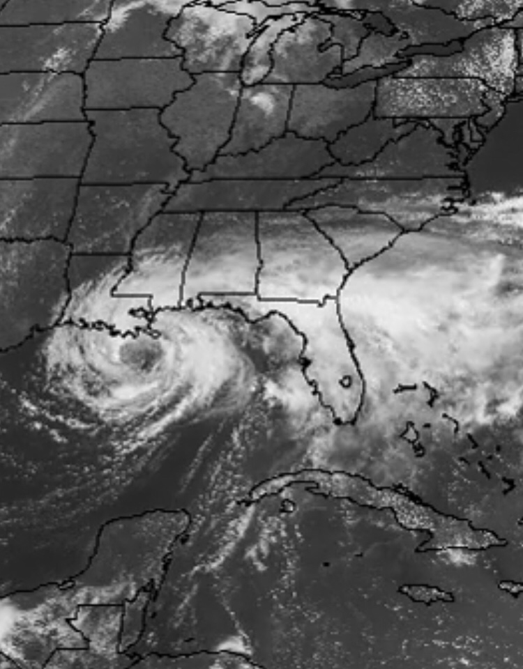
The “eye” is a cloud free area that forms in the center of the storm. It is caused by intense adiabatic compression. A “wall cloud” surrounds the eye with the most intense upward vertical motions of the storm occurring. Further out from the eye “rainbands” form. These bands spiral towards the storm and feature intense upward vertical motions with heavy convective activity.
Winds. Maximum cyclone winds coincide with the wall cloud in an area about 5 to lOnm wide. Winds weaken rapidly towards the eye center (an area of subsidence). The eye may be as small as 3nm or as large as 100nm across. The cyclonic outflow in the upper troposphere is a relatively small area surrounded by anti-cyclonic flow. Maximum outflow of mature storms is usually seen near 39,000 feet.
Temperatures. Tropical cyclones are warm core systems. Their primary energy source is latent heat of condensation released in the wall cloud and spiral rainbands. A secondary source of energy is given by sensible heat from the ocean surface.
Clouds. Convection tends to form in concentrated bands (rainbands) and in the wall cloud. Tops as high as 49,000 feet are not uncommon. Outflow aloft created a nearly continuous mass of cirrostratus surrounding the eye of the storm.
Weather. Extremely heavy precipitation falls beneath the wall cloud and rainbands of intense cyclones. The strongest winds at the earth’s surface (excluding tornado winds) are caused by intense tropical cyclones. Destructive storm surges accompany mature cyclones; this is often the worst effect of the storm along low coastal areas. The most severe weather is usually confined to the right front quadrant of the storm (relative to movement). This area adds the vector speed of the storm movement to the maximum wind speed associated to the storm.
Tropical Cyclone Life Cycles and Classifications
Formative Stage. Also called the “incipient stage”, the formative stage has winds 63 knots and a disorganized cloud pattern with an apparent circulation. Surface pressures are generally 1000 mb or greater.
The following are tropical cyclones in the formative stage:
- Tropical Disturbance. -Sustained winds are 33 knots with no closed isobars.
- Convective activity is 100-300 nm in diameter.
Tropical Depression. Sustained winds 33 knots, circulation is apparent, and at least one closed isobar present. The storm is assigned a number at this stage. (TD #5)
Tropical Storm – Sustained winds are 34-63 knots inclusive, numerous closed isobars and significant surface pressure falls. A name is assigned to the storm at this stage. (TS Harvey)
Immature Stage. This stage is also called the “intensification stage”. Winds will be 64 knots, the cloud pattern becomes more organized, eye formation occurs, numerous closed isobars, and spiral bands develop. This stage lasts from the onset of hurricane / typhoon intensity until the maximum winds
and lowest pressures are reached. The name will be the same as the tropical storm.
The following is used for identification and classification of a storm:
- Typhoon. The storm is called a typhoon if it forms in the Eastern Hemisphere (0° to 180° E).
- Hurricane. A hurricane forms in the Western Hemisphere (0° to 180° W)
- Saffir-Simpson Scale: Places the hurricane / typhoon into one of five categories, based on strength of sustained surface winds:
- Category 1- winds 64 to 82 knots. Central pressure of 980 mb or more. Surf 4 to 5 feet. Minimal damage.
- Category 2- winds 83 to 96 knots. Central pressure of 965 to 979 mb. Surf 6 to 8 feet. Moderate damage.
- Category 3-winds 97 to 113 knots. Central pressure of 945 to 964 mb. Surf 9 to 12 feet. Extensive damage.
- Category 4- winds 114 to 135 knots. Central pressure of 920 to 944 mb. Surf 13 to 18 feet. Extreme damage.
- Category 5- Winds >135 knots. Central pressure <920 mb. Surf >18 feet. Catastrophic damage.
Mature stage. This stage lasts from the time the storm reaches maximum intensity until it begins to decay. During this stage the surface pressure stops falling, the area of maximum winds expands outward from the center, and the spiral band cloud pattern expands.
Decaying stage. This stage begins when the storm weakens below its maximum intensity. A storm may decay if it recurves over land, moves into colder water, or moves into an area with stronger vertical wind shear. Tropical cyclones in the decaying stage may reintensify to the immature or mature stage. The life cycle of a tropical cyclone varies significantly from storm to storm. Some stages of development may be reached more than once, while some stages may be missed altogether.
Cyclone Transition to an Extra-Tropical System
Characteristics. As a tropical cyclone begins to lose its warm core characteristics and become baroclinic, it is termed “extra-tropical”. As the cyclone becomes extra-tropical, the concentrated winds at the center of the storm will decrease as the storm area expends. The precipitation shield will also expand outward with an overall increase in rainfall amounts. The closed circulation aloft will weaken and may give way to a wave pattern. Cold surface air will replace the warm core. At this point, the storm will usually accelerate northeastward.
Tropical Cyclone Recurvature
Recurve towards a Frontal Boundary. Storms will often recurve northward and “merge” with a frontal boundary. Previous frontal movement may be slowed as the low-level latent heat associated with the cyclone forms a wave on the frontal boundary. If the surface front is weak, the cyclone may appear to continue northward “through” the front. The upper support for the cyclone will merge with the upper-level trough at approximately the 500mb position. The cyclone support will normally move rapidly northward along the trough. If the upper trough contains a baroclinic low, the remains of the cyclone will overtake it and merge. Rapid intensification will usually occur.
A change in direction of movement consistently more eastward as the storm moves poleward.
Indicators
A long wave or large-amplitude short-wave trough to the west or northwest of the storm and within 25° of latitude can cause the storm to recurve to the north. If the base of the upper-level westerlies lowers to 15,000 – 20,000 ft ahead of the storm center, the storm will begin to recurve. This indicates that the storm is moving out of the “deep easterlies.” A cyclonically-curved moisture boundary (indicating a low) approaching within 15 degrees latitude of the storm center also favors recurvature. A break in the subtropical ridge could cause the storm to recurve as it seeks lower pressure. The forecaster uses the surface analysis to determine if this could happen. If no other indicators are present the mean climatological track may indicate that the storm will begin to recurve.
Path of Recurvature
The path of recurvature tends to follow a trough poleward between two anticyclonic cells; this is especially true if the trough is evident at 500 mb. If the storm is moving to the west under an anticyclonic cell, it should recurve on the western side.
Radius of Recurvature
A stationary or slowly progressive long-wave pattern with the subtropical ridge having a slight southeast stack would indicate a wide radius of recurvature. This is because the movement of the storm toward the trough is the primary mechanism causing the recurvature. The storm would maintain a constant speed and intensify or gradually speed up and decay. A moderate to fast progressive long-wave pattern or a large amplitude short wave both indicate a small radius of recurvature. This is because the movements of the upper-level trough and the storm are toward one another. This would speed up the recurvature process. The cyclone may initially slow and intensify as it moves into the SE quadrant of the upper-level trough. It will then begin to recurve, speed up, and decay rapidly.
Global Climatology
Over a normal year, 80 tropical cyclones develop worldwide. The Western North Pacific accounts for 33% (26) of the world’s cyclones. The second most active area is the Eastern North Pacific, averaging 13 cyclones a year (16%). The North Atlantic sees an average of 9 cyclones (11%) and the North Indian Ocean accounts for 6 (8%) per year. Combined areas in the Southern Hemisphere, ranging from Africa to the South Pacific, account for 31% (24) of the average yearly cyclones.
El Nino/SouthernOscillation (ENSO)
El Nino
An irregular period of climatic swings which result in warmer than normal sea surface temperatures for large areas. The warmer waters, changing climatic norms alter atmospheric circulation.
Areas effected by El-Nino may have either greater or lesser rainfall amounts and tropical storm activity when compared to climatology. For instance, the Pacific Northwest will receive less precipitation and Southern California will receive more.
Research into why El Nino starts, persists, and ends has made great strides in recent years. The main reason is data collection. Data collection buoys that have been placed in strategic locations can provide the scientist with necessary data to determine when an El Nino event is beginning. The data that is most useful is sea surface temperatures (SST) and winds.
The parameters of SST and winds are important in determining if El Nino is setting up. Over the Pacific Ocean where the easterly tradewinds dominate is the area of concern. A weakening of the easterlies signals the onset of a possible El Nino event. This weakening wind reduces the effect of upwelling and permits warmer waters to invade the Eastern Pacific. This change is the distribution of the SST’s has a dramatic effect on the climate.
The weakening of the wind and eventual warming of the SST’s also causes a seesaw variation in the Pacific atmospheric pressures. Under normal conditions a high-pressure center sits in the central Pacific and low pressure is positioned over Indonesia. The winds of these systems act together to keep the water warm in the Western Pacific. Alsojit helps to keep the water cool in the eastern Pacific. During an El Nino year the pressure systems reverse in which high pressure is found over the Western
Pacific and low pressure over the Eastern Pacific. This change of pressure is known as the El Nino/Southern Oscillation (ENS0).
On the average El Nino comes once every 4-7 years. The earliest means of prediction that were attempted used the frequency of occurrence as a forecasting tool. Scientists used past occurrence to determine when the next El Nino would occur. With greater data collection capabilities the chance of a more accurate forecast becomes more realistic.
El Nina
The warm water off the western South American coast is replaced by cooler water. As the easterly tradewinds strengthens, upwelling off the western South American coast intensifies. La Nina generally follows the El Nino episode. Colder than normal ocean temperatures in the equatorial Pacific act to inhibit convection. Further west over Indonesia, Australia, and Northern South America, the La Nina episode may be wetter than normal, while in the midlatitudes, low pressure tends to be weaker than normal. There is a slight increase in the number of Atlantic hurricanes.
Notes
The deep and shallow easterlies are the primary circulation patterns in the tropics. Secondary circulations include tropical waves and vortices at the low, middle, and upper troposphere. Tropical cyclones have specific formation requirements and exhibit indicators as to their development. Tropical cyclones experience a life cycle similar to the wave-cyclone cycle in the mid-latitudes. The formative, mature, and dissipating stages have specific criteria. The formative stage is further sub-divided into tropical disturbance, depression, and storm classifications. El Nino is a climatic temperature swing that results in changed weather patterns.
Recent Posts
Determining Severe Weather Based On Stability Indexes and Upper-Level Winds
There are several weather products used to determine the possibility of severe weather for an area. The most common and misunderstood by many weather enthusiasts is the Skew-T chart and the upper-air...
Tornado Basics, Severe Weather Preparation, & The Enhanced Fujita scale
Earth's weather can produce various kinds of windstorms which include waterspouts, dust devils and tornadoes. Although they have the common features of a column of rotating air, they are actually...